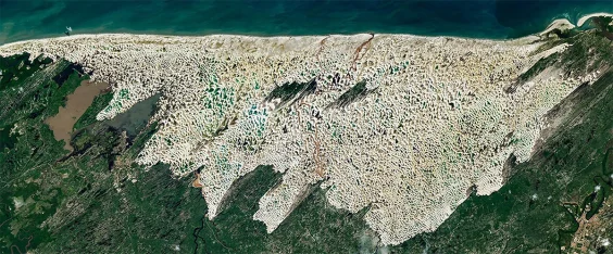
To fully appreciate the spectacular contradictions of Lençóis Maranhenses National Park in northeastern Brazil, you really need to see them from above—namely, from images taken by the NASA Landsat 9 satellite.
What makes the region such a paradox, as these shots show, is that it mixes vast sandy dunes with an astounding number of freshwater lagoons. Basically, it’s a desert with an oasis everywhere you turn.
The dune fields cover some 350 square miles, approximately the size of New York City, and the dunes themselves can reach heights of nearly 100 feet, pushed across the terrain by blustery trade winds from the east during the dry season.
Adding to this surreal landscape is the supply of quartz sand, which has built up over hundreds of thousands of years and been pushed and pulled by changing sea levels. Then there’s the rain—around 50 inches per year, or a little more than you could expect in Seattle and more than double San Francisco’s annual allowance.
Read more: “The Amazing, Autotuning Sandpile”
The dunes, surrounded by the mangrove and restinga forests that make up the rest of the park, are also right in the middle of three distinct biomes in Brazil: the Amazon rainforest, the Cerrado savanna, and the shrublands and forests of the Caatinga.
All of those factors contribute to the dramatic images you see here, captured last month when the lagoon levels peaked. Of note as well are the eye-catching shifts in lagoon colors, caused by different depths of water, and the buildup of sediment, algae, and dissolved organic matter.
Home to more than 850 species, the park was declared a UNESCO World Heritage site in 2024, and NASA’s satellites are keeping a close eye on it. The dunes are traveling west at a rate of 13 to 82 feet per year (a fair clip for dunes), and the dune field as a whole has extended westward by nearly a third of a mile over the last two decades.
Satellite imagery also helps explain the park’s name: In Portuguese, Lençóis Maranhenses means “the bedsheets of Maranhão”—an apt description of how these dunes and lakes appear from the sky.
Lead image: NASA Earth Observatory / Michala Garrison