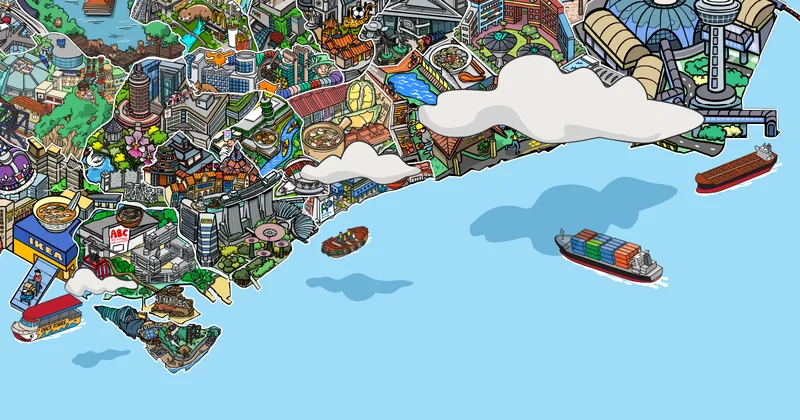
Singapore turns 61 with a population of 6.11 million living in 24 towns and three estates. Each is designed with features to reflect its history. Learn how these places are unique in The Straits Timesâ illustrated tour of the sunny island.
Central
The birthplace of modern Singapore is now a blend of heritage and high-rise architecture. Branching out from the city towards the Central Catchment Nature Reserve, the central region is the largest of Singaporeâs five regions and is where the most mature housing areas are located.
Bukit Timah
An upscale neighbourhood known for its prestigious schools, Bukit Timah likely got its name from the Malay term for âtin-bearing hillâ, or possibly a misinterpretation of âhill of the temak treesâ. It hosts Singaporeâs tallest hill and one of its largest patches of untouched forest. History lives on at the Bukit Timah Railway Station, one of just two surviving stations from the old line that once linked Singapore to Kuala Lumpur.
Queenstown
Named to celebrate the coronation of Queen Elizabeth II, Queenstown is Singaporeâs first satellite town. British planners started developing it and the HDB took over later. Tanglin Haltâs now-demolished âchap lau chuâ blocks once appeared on the Republicâs one-dollar note, which has been discontinued. After the Bukit Ho Swee fire in 1961, the town became the home of many who had been affected by the fire. Today, crowds hunt for furniture at Swedish furniture chain store Ikea, or for sporting goods at Queensway Shopping Centre.
Bukit Merah
Meaning âred hillâ in Malay, Bukit Merah is named for the areaâs red soil, which a folk tale attributes to the blood of a boy who was killed by a jealous ruler after the youngster saved Singapore from attacking swordfish. The town includes Tiong Bahru, the islandâs first public housing estate by the HDBâs colonial predecessor, celebrated for its Art Deco architecture; and the southern coast's highest peak, Mount Faber Park, where tourists can take the cable car to recreational island Sentosa.
Central Area
Developed along the Singapore River, the Central area began as an administrative and commercial centre planned during British colonial rule. Today, it is a glitzy financial hub where shophouses meet skyscrapers. It encompasses enclaves such as Chinatown and Little India, as well as the Civic District, where grand colonial-era buildings have been repurposed as art venues set against Singaporeâs futuristic skyline.
Kallang/ Whampoa
Kallangâs name could have originated from a group of sea-based nomads, the Orang Kallang, or the Malay word for mill. It housed Singaporeâs first airport in 1937, the Kallang Gasworks that supplied the first piped gas here for street lighting, and beloved amusement parks New World and Happy World. Kallang remains central to the Singaporean identity, and is home to the past and present National Stadium, where crowds created the iconic Kallang Wave and Kallang Roar. The National Stadium at The Kallang is the venue for the 2026 National Day Parade.
Marine Parade
This is Singaporeâs first housing estate to be built entirely on reclaimed land, a sought-after coastal residential hub that had evolved from a seaside promenade. The weathered Choa Bungalow, or Sea Breeze Lodge, marks where the shoreline once ended. Residents and visitors exercise at East Coast Park, shop at Parkway Parade â one of the biggest malls in the 1980s â and dine at the colourful Peranakan shophouses in nearby Joo Chiat.
Geylang
The origins of Geylangâs name have been debated. The name possibly referenced the Malay word for mill or the seafaring Orang Kallang. Historically, the area is shared between the Malays in the eastern section, which became Geylang Serai, and the Chinese immigrants who ran businesses in the alleyways known as lorongs. Today, Geylang is a destination for tourists drawn to its shophouses and iconic food offerings such as frog porridge and beef kway teow.
Toa Payoh
Named after the local Hokkien colloquialism for âbig swampâ in reference to its former terrain, Toa Payoh is one of Singaporeâs oldest housing estates. It was the first town planned and built solely by the Housing Board, which was established in 1960 to tackle Singaporeâs housing shortage. It remains at the heart of public housing, as this is where HDB Hub, the statutory boardâs headquarters where new home owners collect the keys to their flats, is located.
Bishan
The roots of Bishanâs name and pavilion-inspired HDB roofs can be traced to Peck San Theng, a Chinese cemetery meaning âPavilions on the Jade Hillsâ. The estate houses the Republicâs first 30-storey public housing blocks and Bishan-Ang Mo Kio Park, a birdwatching area crowned by a naturalised waterway. Residents frequent Junction 8, a shopping centre next to the train depot that references Bishan MRTâs original station code.
West
Under the Urban Redevelopment Authorityâs 1991 Concept Plan, Singapore was divided into five regions, with four regional centres to ease congestion in the city centre. This led to the development of Jurong East as a regional centre for the west.
Clementi
Named after a Straits Settlements governor, Clementi was developed as one of the HDBâs earliest towns in the 1970s. Older residents would recall watching films at the now-defunct Empress Cinema. A sense of history remains through the Old Jurong Line, a disused railway track reclaimed by nature. The town also houses Clementi Mall, the first development by HDB to integrate public housing, retail and a bus interchange.
Jurong East
The name Jurong is likely derived from the Malay word for shark. The development of the Jurong area began in the 1970s. Jurong East features the interconnected malls of Jem, Westgate and IMM, and hosts many school field trips at the Science Centre and Jurong Lake Gardens. It holds fond memories for residents who experienced âwinterâ at the defunct Fuji Ice Palace and soon-to-close Snow City.
Jurong West
Its swamps, hills and forests have been transformed since the 1960s into an industrial estate with low-cost worker housing and, subsequently, a residential town. It hosts Jurong Point, a haunt for students of Nanyang Technological University, Singaporeâs second university; and the Singapore Discovery Centre, which showcases the nationâs past, present and future.
Tengah
HDBâs newest town takes its name from a former gambier and pepper farm. In 1939, the British built an airfield here, which was taken over by the Republic of Singapore Air Force. As the areaâs brick-making factories shut and villagers moved away, nature reclaimed the land. In 2016, HDB announced that Tengah would become Singaporeâs first âForest Townâ planned with town-wide smart technologies, pioneering a centralised cooling system in an HDB estate.
Bukit Batok
Meaning âcoughing hillâ in Malay, Bukit Batok could have taken its name from the blasting sounds heard at its now-defunct granite quarries, one of which has been turned into the scenic Little Guilin park. Its hilltop once held two World War II memorials, which were later replaced by a TV transmission tower. Its past is commemorated in the newly revamped library at West Mall. Aspiring drivers in the west will be most familiar with the area because of the soon-to-close Bukit Batok Driving Centre.
Choa Chu Kang
Taking its name from a local headman who owned the land, Choa Chu Kang is famed as the resting place of Singaporeâs last wild tiger. In the 1970s, the areaâs villages, which sprang up around gambier and pepper plantations, made way for residential neighbourhoods. Today, the town is served by one of Singaporeâs three Light Rail Transit (LRT) systems. Its latest attraction, The Bricks, is Singaporeâs first professional BMX cycling track.
Bukit Panjang
Bukit Panjang was briefly called Zhenghua in the 1980s. The town then reverted to its more popular old name, which means âlong stretches of hillsâ in Malay. Once dotted with villages, the housing estate is serviced by Singaporeâs first LRT network. Residents enjoy walks at the man-made floating wetland Pang Sua Pond, and shop at Hillion Mall and Bukit Panjang Plaza. Islandwide, the town is known as a supper haunt for its springy Koka noodles.
North
A quieter, greener Singapore unfolds up north. Once home to naval bases and rubber plantations, the region houses reservoirs, nature parks and the iconic Singapore-Malaysia gateway, one of the worldâs busiest land border crossings. Plans to further develop the regionâs centre, Woodlands, into an economic hub were announced at the 2025 National Day Rally.
Yishun
The northern town, which has an unfortunate reputation among Singaporeans as the site of bizarre incidents, takes its name from the Mandarin translation of the name of the pineapple king and rubber magnate, Lim Nee Soon. Despite urbanisation, it has retained a rustic charm epitomised by the Upper and Lower Seletar reservoir parks and Jenal Jetty, often called Singapore's last fishing village. Among the many family-run businesses in modern Yishun is Chong Pang Nasi Lemak, named after Lim Chong Pang, Nee Soonâs son.
Sembawang
Named after the Sembawang tree, the area was historically the site of businessman Lim Nee Soonâs rubber estate and a British naval base. Colonial-era houses and streets named after warships and admirals carry its maritime legacy. Another heritage landmark here is Masjid Petempatan Melayu Sembawang, a traditional Malay mosque built by the community. Today, Sembawang also draws visitors looking to relax and soak their feet at Singaporeâs only hot spring park.
Woodlands
Named for its forested appearance when viewed from Johor, Woodlands transformed from kampungs and plantations into a town from the 1970s. Under the British Government, construction of the Causeway, Singaporeâs gateway to Malaysia, began in 1919 and took about five years to complete. Woodlandsâ maritime heritage lives on at Woodlands Waterfront Park, which preserves a jetty from a former Malaysian naval base.
North-East
The region holds several of Singaporeâs youngest towns, which sprouted from former fishing villages. It is also a test bed for some of the Republicâs newest technologies and eco-friendly ideas.
Ang Mo Kio
In Hokkien, Ang Mo Kio means âred-haired manâs bridgeâ, a possible reference to a British surveyorâs bridge over the Kallang River, or the nine bridges villagers used to cross between present-day Lorong Chuan and Upper Thomson Road. It pioneered Singaporeâs town council concept. This mature estate is home to the bustling AMK Hub, the nationâs only circular point block built by HDB and the islandâs largest bird-singing club in Kebun Baru.
Serangoon
Serangoonâs name could have originated from âRanggongâ, a bird once common in local swamps, or from gongs used to scare away animals from the forested area. Today, the housing estate is famous for the bustling Nex mall. Food lovers are drawn to Serangoon Gardenâs Chomp Chomp Food Centre, a smoky supper spot known for its late-night barbecued meats and Hokkien mee.
Hougang
Hougangâs name, derived from the Hokkien and Teochew term âau kangâ, meaning âriver endâ, is a reference to its location at one end of Sungei Serangoon. Early residents hailed from Kampung Punggolâs Teochew community, a legacy still visible in street names and landmarks such as a well marking the former Teochew village in Hougang Street 21. Singaporeâs oldest temple dedicated to the Taoist Nine Emperor Gods and the Instagram-worthy Rainbow Block are found here.
Sengkang
It was originally known as Kangkar, a reference to the fishing villages along Sungei Serangoon and Sungei Punggol. The area was transformed into a township in the 1990s. Sengkangâs nautical past lives on in district names and the maritime-themed Compass One mall. It boasts one of the Republicâs largest man-made wetlands at Sengkang Riverside Park, and the Leong Nam Temple, famed for its grand Nine Emperor Gods Festival celebrations. Sengkangâs LRT network was designed and built alongside the townâs construction. Stations, for example, are located near residential blocks, so residents do not have to walk more than 400m to one.
Punggol
Originally a Malay fishing village, Punggol has been developed into Singaporeâs premier 21st-century waterfront town, anchored by Punggol Waterway. The origins of its name are a mystery, with some suggesting that it means a place where fruit and forest produce are offered for wholesale. As the Republicâs first Eco Town and a living laboratory for the Housing Board, it serves as a test bed for sustainable solutions and technologies, and is home to tech business park Punggol Digital District. Amid this modernisation, a nostalgic orange-and-white bus stop stands as a memento of the past.
East
The eastern region of Singapore is where kampung roots meet coastal living. Famed for its food scene and beaches, and being a gateway to the world via Changi Airport, it has many locals proclaiming: âEast side, best side.â
Bedok
The gateway to Singaporeâs east has its roots in coastal fishing villages and plantations. Bedokâs name likely derives from the Malay word for a riverine fishing boat or a wooden drum once used to call Muslims to prayer. Bedok Reservoir, where the park is a popular jogging spot, was carved out from excavation for reclamation works. Soil from Bedok helped form East Coast Park, Singaporeâs most popular park. Today, the Bedok 85 Market draws foodies craving bak chor mee.
Tampines
Named for the once-abundant Tempinis tree, Tampines has transformed from sand quarries supplying construction and reclamation projects into an award-winning town. It features Singaporeâs first integrated community and lifestyle hub, Our Tampines Hub, which includes a regional library, a hawker centre and a stadium. Quirky landmarks here have endured too, such as the towering void deck at Tampines Street 45 and the Esso stationâs tiger statue â made famous by the local sitcom Donât Worry, Be Happy in the 1990s â which moved from Tampines Avenue 7 to Avenue 9.
Pasir Ris
The name was likely derived from the Malay terms for sand and shred, in reference to its beachfront. The resort town of Pasir Ris traces its roots to kampungs and villages. It is a hub for family recreation, with attractions like Downtown East and Pasir Ris Park. The town also holds a bittersweet place in the hearts of many men, who had to transit here during their national service days as recruits heading to Pulau Tekong for basic military training.