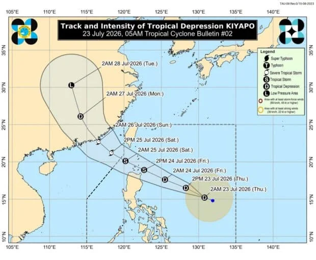
The state weather bureau released a track and intensity forecast for Tropical Depression Kiyapo at 5 a.m. on Thursday, July 23, 2026. — Photo from DOST-Pagasa/Facebook
MANILA, Philippines — Tropical Cyclone Wind Signal No. 1 was hoisted over several areas over Northern Luzon due to tropical depression Kiyapo, formerly a low-pressure area, the state weather bureau said.
Philippine Atmospheric, Geophysical and Astronomical Services Administration (Pagasa) weather specialist Chenel Dominguez reported during a 5 a.m. weather advisory on Thursday that Wind Signal No. 1 was placed over the following areas:
- Batanes
- Cagayan
- Babuyan Islands
- Isabela
- Apayao
- Abra
- Kalinga
- Eastern and central portions of Mountain Province
- Eastern and central portions of Ifugao
- Ilocos Norte
- Northern portion of Ilocos Sur
- Northern portion of Aurora
READ: LPA’s trough bringing rains over parts of PH – Pagasa
Article continues after this advertisement
“We have raised Tropical Cyclone Wind Signal No. 1 with a 36-hour lead time before the strong winds brought by Typhoon Kiyapo are felt, to allow everyone time to prepare,” Dominguez said.
As of 3 a.m., Kiyapo was estimated 950 kilometers east of Central Luzon with maximum sustained winds of 45 kilometers per hour near the center and gustiness of up to 55 kilometers per hour, according to Pagasa.
Throughout the passage of Kiyapo, it is expected to intensify into a tropical storm category on Friday with the highest wind signal being raised is Wind Signal No. 2, Dominguez said.
“It is still far from our landmass. We anticipate that it could intensify into a full-fledged tropical storm by tomorrow, at which point the highest tropical cyclone wind signal raised would be Wind Signal No. 2,” she stated.
She added that the weather disturbance is forecast to closely approach or make landfall over Babuyan Islands. However, based on Pagasa’s cone of probability, the chances of Kiyapo making landfall over Cagayan is still high.
Article continues after this advertisement
“It is possible that it will make a close approach or landfall here in the Babuyan Islands. But we can see from the track that Cagayan is within our cone of probability. So we are not ruling out the possibility that it will make landfall here,” she explained.
Kiyapo is forecast to exit the Philippine area of responsibility on Saturday as a severe tropical storm.
Article continues after this advertisement
“By Saturday, it will exit the Philippine area of responsibility, and we foresee it intensifying into a severe tropical storm,” Dominguez said.
The trough of Kiyapo is expected to bring gloomy skies with scattered rains over Bicol Region, Eastern Visayas, and Romblon on Thursday.
Meanwhile, the southwest monsoon, or habagat, is expected to continue affecting the western section of Southern Luzon, Visayas, and the rest of Mindanao.
Your subscription could not be saved. Please try again.
Your subscription has been successful.
Localized thunderstorms may prevail over Metro Manila and the rest of Luzon, according to Pagasa. /das