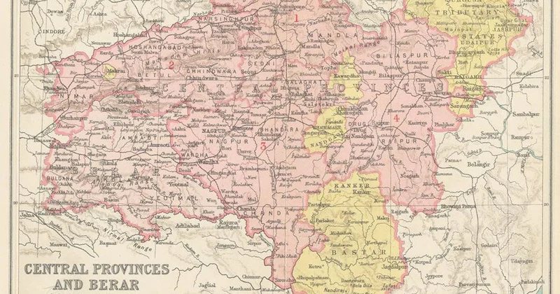
Abujhmad, a captivating expanse of hills, woods and streams, holds a special place in the contemporary history of Bastar. One of the first journalist–researchers to explore this region was Ramesh Chandra Roy, joint editor of the Ranchi-based anthropology journal Man in India. His groundbreaking venture in 1934 shed light on this enigmatic land. This ethereal wonderland was known by another name. The locals, the Hill Marias, called it Metabhum, meaning highland. In contrast, they referred to the lowlands as Dorbhum.
Scottish officer Glasfurd ventured into this region in 1862 with forest explorer FG Stewart. Glasfurd used the spelling Ubujmard. Eight years later, The Gazetteer of the Central Provinces of India, published in 1870, referred to it as Abajmard, also introducing a synonym – Madian.
Interestingly, the name Abujhmad, which translates to “highland that cannot be understood”, was not adopted by the local inhabitants. This label was imposed from the outside.
The mystery captivated me. Did locals still whisper the old name, Metabhum, or had Abujhmad become their tongue? In May 2017, I visited Kanhargaon, a village nestled on Metabhum’s edge. Just days before my visit, a group of Maoists had ambushed a police party with gunfire. During the ensuing clash, the police raided a Maoist camp and seized various items, including black uniforms, wires, firecrackers, medicines, silk threads and notebooks. As I was clicking photos, two items in particular caught my attention: a red fabric poster in Hindi issued by the CPI (Maoist) calling for the observance of “martyrs week” between July 28 and August 3, listing the names of four “martyrs” – Bijay, Laksminath, Sunil and Reeju; and a pamphlet urging locals to resist the police to preserve the sanctity of jal, jangal and jameen (water, forest and land).
The following year, I reported from Orcha, a block headquarters, and in 2023, I visited Kohkameta, a large village recently connected by a motorable road. “Even today, we call this place Metabhum,” said a Hill Maria schoolteacher to me, supported by an elderly man who nodded in agreement. “Whenever we see a hill, we call it meta.”
I confirmed this by checking a map I had scanned and uploaded to my phone. The nomenclature of the villages – Padmeta, Metabeda, Tekameta and Orchhameta – each resonated with the enduring presence of “meta” in their toponyms. While the designation Abujhmad may hold sway for outsiders and officials, for the Hill Marias, their ancestral name remains undeniably Metabhum.
I firmly believe it’s time to ditch Abujhmad and embrace the beautiful name of Metabhum.
Flashback to 1934: Editor Roy ventured through the harsh, unforgiving terrain of Metabhum, camping in the hamlets of Orcha, Adeq, Itulnar, Hilmi and Handawada. During his journey, he conducted an anthropometric study on a hundred Hill Marias – all males – determining that their average height was 5 feet 4 inches. Roy observed that their skin tones varied from pale wheat to light black, with nine individuals being light brown, sixty brown, sixteen dark brown, and fifteen light black. He noted that the Hill Marias had thick hair on their heads and very little on their bodies, with their wavy hair being either black or dark brown.
The unique features of the Hill Marias prompted anthropologists to ponder the slight but definitive Mongoloid element among the tribespeople. It’s important to note that Roy never used the term Metabhum in his notes. It’s possible he wasn’t familiar with this local nomenclature. By 1934, Abujhmad (his spelling: Abujhmar) seemed to be the prevalent term, and he used it throughout his seven-page report.
Roy also documented his observations about the Hill Maria women. However, in the interest of respecting cultural sensitivities, let us refrain from including his specific remarks about their physical features.
Overall, Roy’s conclusion, when stripped of anthropological jargon, was straightforward: The Marias exhibited three racial affinities – pre-Dravidian, Dravidian and Alpine. This was significant because British civil servants and researchers avidly pursued the study of these indigenous groups. John Henry Hutton (1885–1968), an ICS officer turned professor at Cambridge University, firmly believed in a Mongoloid element among the Marias. He was sceptical of Roy’s claim that no instances of the epicanthic fold were found in Bastar. Hutton observed several similarities between the Marias of Bastar and the highlanders in north-east India, though he admitted lacking scientific proof for his assertion. Hutton wrote: “…shooting stars are ‘star-dung’ alike to the Sema Naga and the Maria; like the Maria, Ao Naga dances with bells on his buttocks. That incest and other breaches of taboo are visited on the offenders or their kin by man-eating tigers is a typical Naga belief, and the inheritance of his father’s house by the youngest son a common Naga practice…”
In 1929, German anthropologist and expert on Andaman tribes, Egon Freiherr von Eickstedt, also traversed the rugged woodlands of Bastar, measuring the Hill Marias of Handawada.
During his expedition, Eickstedt captured some remarkable photographs of Bastar, including a series depicting the funeral journey of a Hill Maria. One of these black-and-white marvels was aptly captioned, “Mourning over a corpse, Handawada.” To understand where Metabhum is located on the map and its size, we must first examine the geography of Bastar as a whole. Early British maps left a giant blank spot around Bastar.
Back in the late 1700s, famous British geographer James Rennell was piecing together a map of India. He came across a huge empty area in the middle, stretching 300 miles by 250 miles, between the regions of Berar, Golconda, Odisha and the Circars. Rennell guessed this area might be harsh or even deserted and not very useful for British interests. He wasn’t sure how far this “wild country” extended, but he knew the nearest known civilisation beyond the mountains was the Marathas of Berar. Rennell suspected the empty space was “either too desert or too savage to be easily or usefully explored.” In another context, it’s important not to overlook the word “usefully”. What Rennell didn’t know was that this blank space was actually Bastar, a thriving kingdom. Later explorers discovered a flourishing civilisation where Rennell had envisioned a wasteland.
Decades later, British surveyors continued to encounter significant challenges with Bastar. Even as late as 1853, when the Great Trigonometrical Survey of India had been underway for over 50 years, some highlands and jungles in central India were still marked as unexplored. These uncharted areas formed “quite an oasis” on the maps, highlighting the challenges of surveying the region.
Only in 1862, when Glasfurd traversed the territory, did he meticulously document its geographical features. His notes revealed that Bastar was relatively flat towards the east, transitioning into an elevated plateau averaging 1,800–2,000 feet above sea level. The central and north-western regions were mountainous, while the north comprised a mix of rolling plains and dense sal forests. Glasfurd’s observations highlighted lofty hill ranges, with particular mention of Bailadila, a peak near Dantewada resembling a bullock’s hump.
Three major rivers – Indravati, Sabari, and Taliperu – were extensively described, alongside a list of a dozen other streams, including Kotri, Shankhini and Dankini. The soil was characterised as light clay mixed with sand, making it particularly suitable for wet rice cultivation.
In contemporary Bastar, an administrative division within the state of Chhattisgarh, the region of Kanker is also included. However, during the British era, when explorers like Glasfurd documented the area, Kanker was a separate entity, existing as an independent princely state outside Bastar’s control. According to the 1872 census report, Bastar, excluding Kanker, encompassed an area of 13,062 square miles (33,830 sq. km).
While every corner of Bastar boasts distinctive geographical features, the elliptical-shaped Metabhum, a 3,900-sq.-km area in its centre, stands out as its most unique landscape. To the north lie the vast plains of Narayanpur and Antagarh, to the east is the Gudra river basin, the west and north-west are bounded by the Kotri and its tributaries, and the south is delineated by the floodplains of the Indravati River.
Imagine a landmass as vast as Bhutan or Switzerland – that’s today’s Bastar. And cradled within its embrace lies Metabhum. To understand the geographical perspective better, consider this: Goa, known for its stunning beaches, could fit comfortably within the borders of Metabhum.
The terrain of Metabhum rises towards the centre, with the east being higher in elevation than the west. The average ridge height is 2,500 feet above sea level, with the highest point at 3,322 feet located eight miles north-west of the confluence of the Gudra and Baordig rivers.
Understanding Metabhum’s unique geography and history is essential for our study. This isolated region, designated as an anthropological reserve in the early 1930s, remained off-limits to visitors for decades. Metabhum became a place where time seemed to stand still, untouched by the outside world.
Grigson’s office memorandum of 1931 clearly articulates the concept of isolating the Hill Marias: ‘… interference with these most interesting primitive people will be reduced to a minimum, and in fact their country will become a sort of aboriginal reserve, well worth leaving to itself in the interests of anthropology. Their country is poor and never likely to be worth development and there is nothing at all to be gained from interfering with the primitive life of these people.’
Reading between the lines, it becomes evident that the British would not have left the tribe undisturbed if Metabhum had contained significant recoverable economic resources such as timber or minerals. This lack of economic incentive likely played a role in the decision to isolate the tribe.
A year later, in 1932, Bastar administrator DR Rutnam emphasised the importance of leaving the Hill Marias undisturbed. His directive, addressed to all heads of departments, subdivisional officers and managers of Kutru and Bhopalpatnam zamindaris instructed officials to minimise their presence in the area.
This move aimed to preserve the tribe’s tranquillity and isolation as much as possible. As a result of these restrictions, outside influences began to fade rapidly in Metabhum. The administration thus pulled out its officials from the area. After India’s Independence, domestic policymakers reluctantly adhered to the Grigson–Rutnam formula, maintaining Metabhum as an anthropological reserve. They continued the tax collection system introduced during the Raj, preserving the region’s autonomy with local headmen running the administration and collecting taxes. Outsiders were prohibited from entering the terrain without a valid permit.
However, local officers made subtle attempts to modify these rules and integrate the terrain into the mainstream. These efforts failed as the officers and the political establishment of the time hesitated to take bold risks. In the early 1950s, for instance, the then deputy commissioner of Bastar, RCVP Noronha, opposed the policy of Metabhum’s permanent isolation under the guise of safeguarding the Hill Marias as “specimens of a peculiar species”.
Noronha chronicled his captivating journeys to this terrain in 1950 and again in 1952. When I visited Kohkameta, his diary flashed through my mind. Guided by a local companion named Mukaddam, the only tribesman in the area to own a gun at that time, the officer traversed the terrain with confidence. Those days were marred by frequent man–animal conflicts. Danger lurked around every bend – tigers and bears chasing villagers and herds of wild buffalo trampling crops.
At Kohkameta, Noronha faced a challenging situation when angry graziers urged him to shoot a wild buffalo that had infiltrated a tame herd. After a dramatic chase of the untamed beast – a narrative brought to life with a comedic touch in his notes – the civil officer finally used his aide’s rifle to remove the animal from the forest ledger… permanently. It is worth noting that, if attempted today, such an action would land the officer in jail.
Excerpted with permission from Rebel Bastar: History, Maoism and the Search for Answers in India's Heartland, Shantanu Nandan Sharma, Hachette India.
We welcome your comments at letters@scroll.in.