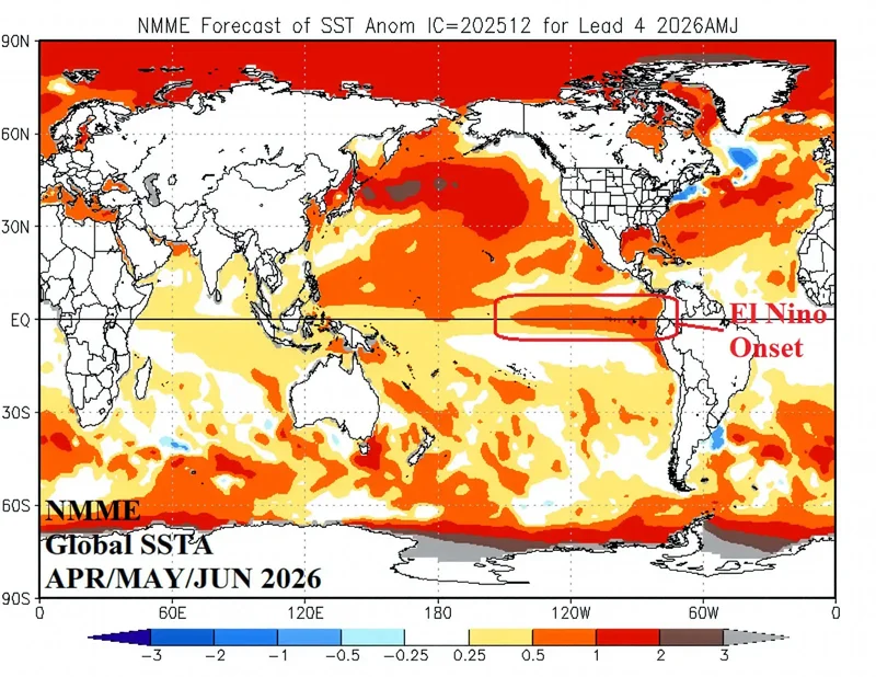
Scientists are warning South Africa to prepare for an unusually early and strengthening El Niño that is likely to bring hotter-than-normal conditions and raise the risk of a drier summer, with climate models indicating it could become one of the strongest events on record.
The biggest concerns are increased heat, pressure on water resources and agriculture, although the severity of rainfall impacts remains uncertain.
Whether it ultimately develops into a "Super El Niño" remains uncertain.What scientists do agree on is that El Niño is firmly established, strengthening and warrants close attention.
El Niño and La Niña are the warm and cool phases of the El Niño-Southern Oscillation (ENSO), a recurring climate pattern in the tropical Pacific that influences weather around the world.
Agricultural meteorologist Johan van den Berg said the current event was unusual because of how early it had developed.
"The usual time of development is from July to September," he said.
"The current El Niño started to develop in May. It can currently already be classified as a moderate/strong El Niño that is very early in the life cycle of El Niño events."
For southern Africa, El Niño has historically been associated with hotter and drier conditions over the summer rainfall region, although no two events unfold in the same way.
The ENSO Reference Group a panel of experts from the South African Weather Service, the Agricultural Research Council, leading universities and other research institutions said El Niño conditions are now "firmly established and continuing to strengthen", developing "against a backdrop of exceptionally warm global temperatures."
While the event is currently classified as moderate, seasonal forecast models indicate a high likelihood it will persist through the remainder of 2026, "with a significant probability of strengthening into a strong or even very strong event by late spring or early summer in the Southern Hemisphere".
However, the scientists stressed that "the strength of the El Niño event does not directly determine the impact", as other oceanic and atmospheric systems can either amplify or reduce its effects.
Although rainfall projections remain less certain than temperature forecasts, the experts said models point to increasing risks of below-normal rainfall across the summer rainfall region by early summer, while confidence is higher that above-normal temperatures and more frequent heatwaves and hot spells will occur from August to December.
"Overall, despite the inherent uncertainty, we emphasise the need to prepare for a dry and warm to hot season."
Van den Berg agreed that South Africa is entering this El Niño from a far stronger position than during previous events.
Dr Mohau Mateyisi, a senior researcher in the Climate & Air Quality Modelling Research Group at the Council for Scientific and Industrial Research, said climate model evidence indicates that ocean temperatures across the equatorial Pacific have been warming rapidly and are expected to remain elevated into early 2027.
"Model evidence suggests that changes in ocean temperature over the Pacific Ocean are becoming warmer than usual and this condition is anticipated to persist into early 2027."
"On comparing thresholds of surface temperatures over the Niño 3.4 [which strongly influences the climate of Southern Africa], we learn that from mid-May to the present date, daily sea surface temperatures (SST) have already exceeded the highest thresholds, at least when comparing 1981 and 2025 records.
"We may recall that during the Niño 3.4 of 2024, global temperatures reached record-breaking thresholds, while the 2015 El Niño was also one of the strongest El Niños.
"The warming of equatorial SST in daily SSTs during mid May [to the] present date has already exceeded that associated with the two recent record-breaking El Niño years.
"The available scientific evidence, as derived from the sea surface temperature anomalies, points to the possibility of the development of a very strong El Niño."
Van den Berg noted that the current event could become only the fourth super El Niño since about 1950, following those of 1982/83, 1997/98 and 2015/16.A super El Niño is defined by sea surface temperatures more than 2°C above normal in the central Pacific.
Mateyisi said the latest international seasonal forecasts point to an increased likelihood of both hotter and drier conditions across much of the country's interior by the early summer October to December 2026 season to the November to January 2027 season.
"The predicted probability of this category occurring by mid-summer is above 50%."
He warned that such conditions could place multiple sectors under pressure."This type of predicted widespread drought is likely to put pressure on health, water, food and energy systems. The biggest adverse impacts are likely to be felt by the most vulnerable populations."
Dr Neville Sweijd, an associate professor at the School for Climate Studies at Stellenbosch University cautioned that a stronger El Niño does not automatically translate into more severe impacts.
"It's important to note that the strength of El Niño or the strength of the ENSO signal... does not always equate to the strength of the impact."
Sweijd said there was greater confidence in forecasts of above-average temperatures than rainfall."The heat is another question. So we have normally got warmer than average summers in an El Niño year and that will affect the whole country; that's a more confident prediction. We can expect it to be warmer on average and that means potentially greater heatwaves."
Climate change effectively raises the baseline from which El Niño operates.
"Global warming means that the background warming is higher. It means that effectively the platform onto which we put the extra warming of the El Niño is higher... The combination of climate change and El Niño is that they exaggerate each other."
Van den Berg agreed that climate change is expected to amplify one of the biggest risks associated with the developing El Niño.
"Global warming is a reality and El Niño events amplify the heat component. The 2026/27 summer season is likely to suffer more heat stress for plants than drought stress."
Looking ahead, Van den Berg said farmers should focus on conserving soil moisture and adapting crop choices to local conditions.
"Grain farmers must manage soil water conditions by preventing water loss from the soil....
"The favourable conditions since about 2020 resulted in farmers reverting back to poorer soils that are now posing the highest risk of drought induced crop failures."
Effective water management will be critical for municipalities and other users.
"It includes water quality. Less water in storage dams results in higher concentrations of chemical and other residuals without the 'luxury' of flooding conditions, removing these elements. Water leaks are one of the main sources of water management failures."
Mateyisi said the available seasonal climate predictions should be considered to inform decision-making, planning and conduct coordination drills for timely response measures.
Governments should raise awareness about the possible impacts of prolonged heat and below-average rainfall, particularly on water resources.
"Regular weather forecast and seasonal prediction updates should be relied upon to inform day-to-day health and safety measures, for example to avoid heat exhaustion, heat strokes and untimely mortality especially for the young and elderly."