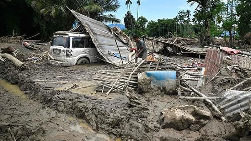
The story so far: Assam is used to the annual floods, but the authorities and the inhabitants of three historically near-untouched districts—Charaideo, Jorhat, and Sivasagar—have borne the brunt this time. The Assam government told the 126-member Assembly on July 23 that the situation has been the worst in 60 years. Scientists say climatic uncertainty is the “new normal” and no part of Assam or the rest of the northeastern region can or hope to stay unaffected.
Why is Assam flood-prone?
Ancient texts regarded Assam as a waterscape, academician Arupjyoti Saikia wrote in The Unquiet River: A Biography of the Brahmaputra. Assam’s geographical alignment—divided into two valleys surrounded by hill States with narrow outlets into Bangladesh—makes it prone to flooding even if it rains heavily in the hills of Arunachal Pradesh or Bhutan. The two valleys, named after rivers Brahmaputra and Barak, are separated by the hills of Karbi Anglong and Dima Hasao districts. These rivers have about 120 tributaries and distributaries. Together, they carry huge volumes of sediments, contributing to the Brahmaputra’s expanding floodplain and extensive inundation, as evident from satellite imagery and flood-extent analyses from the Copernicus Programme, the European Union’s flagship earth observation initiative, and the Global Flood Mapper of the Indian Institute for Human Settlement.
Historically, flooding has been gradual throughout several waves during, before, or after the monsoon months marked by almost evenly distributed rainfall. The rainfall pattern has been changing over the past few decades. Cloudbursts, cloudburst-like situations, long doses of heavy rainfall between longer dry spells leading to fluctuations between floods and drought-like situations, and very heavy rainfall over small areas have been adding to the State’s woes. Infrastructure push in the hills, embankment breaches, and land-use plan changes due to increasing human activities are factors, too.
An occasional cause is the release of excess water from dams upstream; the July 2023 floods in five western Assam districts were attributed to the “controlled” release of water from Bhutan’s Kurichhu dam. However, Nagaland’s 75 MW Doyang dam proved to be a saviour for eastern Assam’s Golaghat district when its three neighbouring districts—Jorhat, Sivasagar, and Charaideo—were flooded almost overnight. Bibhash Sarma, an engineer and consultant for the State’s Water Resources Department, said the dam absorbed flood water and released it gradually to “reduce the flood peak”.
How did three eastern Assam districts get submerged?
The highest number of people—7.21 lakh—affected by the recent floods was on July 23, two days after 21 people were killed across seven districts. Charaideo, Jorhat, and Sivasagar districts on the southern bank of the Brahmaputra accounted for 6.78 lakh affected people, which was more than 94% of the total flood-hit population.
The unprecedented inundation was triggered by massive downstream runoff after extreme rainfall in Nagaland’s Longleng, Mokokchung, Mon, and Longleng districts between July 18 and 20, killing nine people in landslides in Mon town. Persistent heavy rainfall across the affected districts worsened the situation. The Chief Minister said adjoining areas of Assam and Nagaland received 435-490% more rainfall than normal. Meteorologists explained that the upper-air cyclonic circulation, which formed at the lower tropospheric level, produced extreme moisture convergence over already saturated hill catchments along the Assam-Nagaland border and triggered exceptionally heavy rainfall.
India Meteorological Department data showed Wokha received 239 mm of rain over July 18, 19, and 20, while Mokokchung recorded 167 mm, Mangkolemba 211 mm, and Longleng 152.2 mm. On the night of July 18, Sonari in Charaideo district received around 190 mm of rain. From July 16 to 22, rainfall was significantly above normal in several eastern Assam districts—46% in Jorhat, 47% in Sivasagar, and 147% in Golaghat (adjoining Jorhat).
Why is the current situation in focus when Assam has had worse flood years?
Assam is no stranger to fatal floods. The official death toll was 160 in 2017 and 181 in 2022, the year when 78 others were killed in storms and lightning strikes and 55 lakh people were affected across 32 of the State’s 35 districts. However, the deaths and damages were proportionately distributed across the length and breadth of the State, unlike this time.
What makes the crisis in the three districts alarming is their history of being relatively flood-free. People in these districts say the last major flood was in 1950, when a devastating earthquake made catastrophic floods a frequent phenomenon in Assam. Assam’s Parliamentary Affairs Minister Pijush Hazarika told the Assembly that the floods in the eastern part of the State have been the worst in over 60 years.
Chief Minister Himanta Biswa Sarma said people and the authorities in Charaideo, Jorhat, and Sivasagar were caught off-guard as these districts hardly have a history of major floods, unlike other parts of Assam that have been unusually drier this year. Although the 4,426 sq. km area covered by these districts was largely considered to be above normal flood level, there are references to floods in 1691 and 1793 in the chronicles of the erstwhile Ahom kingdom. According to K.K. Chatradhara, an environment activist based in the flood-prone Dhemaji district on the northern bank of the Brahmaputra, the situation in the three districts indicates that the disaster interval in this “safer” part of Assam may have reduced to 50-75 years from more than 100 years.
What are the lessons from this disaster?
One of the promises that the Bharatiya Janata Party rode to end 15 years of Congress in Assam in 2016 was to make Assam flood-free. Experts say this is easier said than done. Environmentalist and former Gauhati University professor, Parimal C. Bhattacharjee, said controlling rivers and other natural water bodies was an invitation to disaster. “You have to let nature take its own course, and learn to live with the flood, as the Mishing community does by building chang-ghars (elevated houses above the normal flood level),” he said.
The Assam government introduced a ‘Living with Floods’ scheme in the 1990s, entailing the construction of raised platforms with drinking water, sanitation, and healthcare facilities. It was withdrawn due to allegations of corruption. However, experts agree that living with floods has become tougher today because of climate change, anthropogenic activities, and infrastructure push. Partha Jyoti Das, a climate, water, and disaster specialist with biodiversity conservation group Aaranyak, said stopping or managing floods is an exercise in futility. “We can monitor, forecast, give early warning, and strengthen our disaster management by decentralising it to the panchayat level where people are trained to sniff an impending disaster and act accordingly, apart from assessing the embankments annually. By coordinating with the neighbouring States, we can minimise the losses and damages,” he said.
“The ever-changing rainfall pattern is the new normal, and the administrative machinery must understand that no part of Assam or anywhere else in the northeast is safe from floods. Everyone needs to be wired to anticipate floods and associated calamities during the six rainy months in the region,” he added.
What are the challenges ahead?
Experts have underlined a flaw of the government’s approach to disaster management: identify risks and concentrate on high-risk areas. “The planning needs to change. If low or zero-risk areas become high-risk overnight, there’s very little people can do, as was the case with the three districts, where administrative preparedness was lacking. Getting the right people for climate-smart or climate-resilient flood management was crucial,” Mr Das said.
The second step, specialists said, is surface water management by undoing or minimising the damage done by unscientific roads, flyovers, hydropower projects, housing, and other infrastructure projects, which have largely claimed wetlands that once acted as water sponges during floods. However, as Bibhash Sarma pointed out, a major challenge is dovetailing old discharge data with the climate change situation. “The old discharge data, based on which design engineers estimate the flood impact on projects for 30-50 years, have become redundant due to the changed situation. Collecting new data is an uphill task because of the unpredictability of the conditions today,” he explained.
Engineers said that factoring in climate change alters designs and increases the size and cost of projects. The authorities invariably veto such modifications because they “do not conform to standards” or are “uneconomical”. The mindset of officials and policymakers needs to change to absorb or minimise the impact of floods, landslides, and other natural disasters, they said.
Published - July 27, 2026 10:58 am IST