'Luis' landfall in Northern Luzon likely
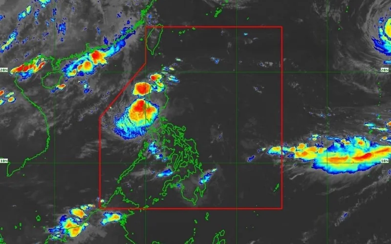
MANILA, Philippines — Tropical Depression Luis may make landfall or pass close to Northern Luzon tonight or early Tuesday after moving to within 135 kilometers east of Casiguran, Aurora, PAGASA said Monday, August 3.
Tropical Cyclone Wind Signal No. 1 now covers Isabela and Quirino, along with parts of Cagayan, Apayao, Kalinga, Mountain Province, Ifugao and Aurora.
As of 7 a.m., Luis maintained maximum sustained winds of 55 kilometers per hour near the center and gusts of up to 70 kph.
The tropical depression was moving northward slowly, with strong winds extending up to 190 kilometers from its center.
Signal No. 1 areas
Signal No. 1 was raised over the central and eastern portions of Cagayan, covering Enrile, Tuguegarao City, Peñablanca, Piat, Santo Niño, Camalaniugan, Tuao, Lal-Lo, Gonzaga, Alcala, Amulung, Santa Teresita, Baggao, Buguey, Solana, Rizal, Santa Ana, Gattaran, Iguig, Lasam, Aparri, Ballesteros, Abulug, Allacapan and Pamplona.
The signal also covered all of Isabela and Quirino.
In Apayao, it was in effect over Flora, Santa Marcela, Conner, Pudtol and Luna.
Signal No. 1 also covered Tabuk City, Tanudan, Pinukpuk and Rizal in Kalinga; Paracelis and Natonin in Mountain Province; Aguinaldo and Alfonso Lista in Ifugao; and Dinalungan, Casiguran, Dilasag, Dipaculao and Baler in Aurora.
These areas may experience winds of 39 to 61 kph, with minimal to minor impacts to life and property possible.
Possible landfall tonight
Luis is forecast to move generally northwestward and may make landfall or pass close to Northern Luzon tonight or early Tuesday. It is then expected to turn sharply east-northeastward and move away from the Philippine landmass.
PAGASA said Luis would likely remain a tropical depression for most of the forecast period.
The cyclone may weaken into a remnant low by Wednesday, August 5, before being absorbed into the circulation of a tropical cyclone with international name Dolphin.
Heavy rain and strong winds may still affect areas outside the possible landfall point and the forecast confidence cone, PAGASA said. The agency warnedm, however, that the forecast track remained highly uncertain and could change in succeeding bulletins.
Gusty winds, moderate seas
Luis and the southwest monsoon may bring strong to gale-force gusts over most of Luzon and the Visayas on Monday and Tuesday.
Similar conditions may also affect Lanao del Norte, Misamis Occidental, Camiguin, Surigao del Norte, Dinagat Islands, Sarangani, Davao Occidental and Davao Oriental.
On Wednesday, gusty conditions may affect most of Luzon and the Visayas, the Zamboanga Peninsula, Northern Mindanao, Dinagat Islands, Surigao del Norte, Agusan del Norte, Davao Occidental and Davao Oriental.
Waves reaching up to 2.5 meters may affect the eastern seaboards of Isabela and Davao Oriental and the northeastern seaboard of Aurora.
Waves of up to 2 meters may affect the seaboard of Batanes; the northern and eastern seaboards of the Babuyan Islands; and several coastal areas of Cagayan, Pangasinan, Polillo Islands, Catanduanes, Camarines Norte, Camarines Sur, Northern Samar, Dinagat Islands, Surigao del Sur, Davao Occidental and Davao Oriental.
PAGASA advised operators of motorbancas and similarly sized vessels to take precautions and, when possible, avoid sailing under these conditions.
The next tropical cyclone bulletin is scheduled for 11 a.m. Monday.
- Latest
- Trending