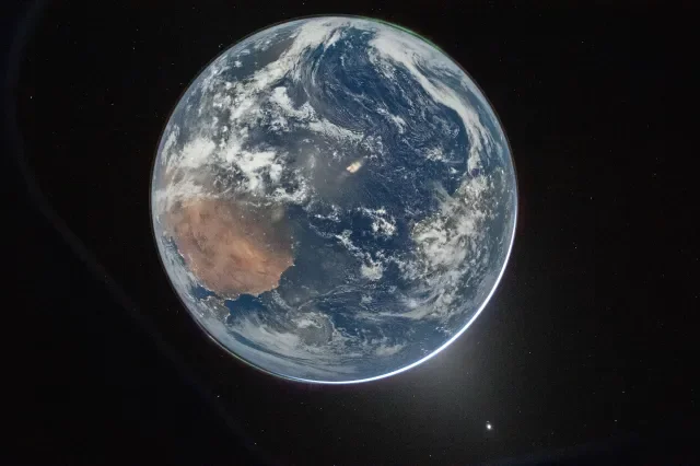
If you gather enough mass together in one place, as long as the individual particles inside aren’t moving too quickly, your mass will become gravitationally bound. If that mass is made out of atoms — particles that can collide, exchange energy and momentum, and stick together — then it can form a solid object as well. If the overall mass is great enough, you won’t just make a solid object that’s gravitationally bound, but you’ll reach a state that’s known as hydrostatic equilibrium: where your object’s shape is determined primarily by a combination of gravity and rotation. If you aren’t rotating at all, you’ll form a sphere, but if you are rotating, you’ll form a “squashed sphere” shape: an oblate spheroid. Atop that overall shape, because we have several layers to the Earth of different densities, the less dense layers “float” atop the denser ones. Earth’s crust, in particular, is made mostly of solid rock, and so has an irregular shape. The crust’s thickness varies from location-to-location tremendously, showing up as features such as mountains, valleys, the ocean floor, and much more. Even though we can measure that the acceleration at Earth’s surface is always approximately the same value — 9.8 m/s² — there’s a slight but substantial difference between high-gravity and low-gravity places on Earth, and those differences actually matter more than you might think. Here’s what determines our planet’s gravity at every point on our surface. This view of the Earth comes to us courtesy of NASA’s MESSENGER spacecraft, which had to perform flybys of Earth and Venus in order to lose enough energy to reach its ultimate destination: Mercury. Several hundred images, taken with the wide-angle camera in MESSENGER’s Mercury Dual Imaging System (MDIS), were sequenced into a movie documenting the view from MESSENGER as it departed Earth. Earth, an oblate spheroid, rotates roughly once every 24 hours on its axis and moves through space in an elliptical orbit around our Sun. Credit: NASA/MESSENGER The simplest model: Earth is a sphere. If all we had was mass uniformly gathered together in one place, and we had enough of it so that the gravitational force determined the shape of that mass, that shape would always be the same one: a perfect sphere. The more massive your object is, the more spherical it becomes; the more uniformly composed it is, the more spherical it can be as well. In our Solar System, the most perfectly spherical object we know of is the Sun: it’s the most massive and composed of largely the same light elements, where 98% of the Sun is made of hydrogen and helium. The Sun largely doesn’t rotate, completing one rotation every 25-to-33 days, depending on its latitude. As a result of these properties, the Sun’s polar diameter is only around 10 kilometers (6 miles) shorter than its equatorial diameter, for a difference of less than 0.001%. In the most extreme cases of all, a very slowly spinning pulsar — an object made almost exclusively of neutrons — the difference between equatorial and polar radii can be as small as one-part-in-a-trillion, or about the width of a single proton. However, because the Earth is much lower in mass than a star or stellar remnant and rotates substantially, the approximation that Earth is a sphere is only good to a certain degree. Although we typically think of Earth as being spherical, the fact that it rotates on its axis distorts it into a slightly oblate spheroidal shape. The Earth compresses at the poles and bulges at the equator, with the equatorial diameter exceeding the polar diameter by about 22 km (13 miles), and an observer at the equator in motion at over 1600 km/hr relative to an observer at either the North Pole or South Pole. Credit: Hellerick/Wikimedia Commons A slightly more complex model: Earth rotates, and is an oblate spheroid. This represents an important step, as rotation is generally the second most important effect — behind gravity — in determining the shape of a sufficiently massive object. While gravity, in isolation, tends to pull objects into spherical shapes, rotation always has a preferred axis: a “direction” that the rotation takes place around. For a solid object, or one that isn’t free to rotate at different rates depending on things like latitude or distance from the object’s center, the addition of rotation alters the object’s shape away from that of a perfect sphere. If your object is solid, it all rotates at the same angular speed: making a single rotation in a given amount of time. For the parts of the object that are close to the rotation axis — the invisible line connecting its poles together — rotation doesn’t add any appreciable kinetic energy to those components. However, the farther away you are from the axis, the faster you move through space, and hence the greater your kinetic energy. Because there needs to be a balance between overall energy (including gravitational potential energy and rotational kinetic energy), this creates a bulge at the equator for the most distant components of the object. Rapidly rotating Kuiper belt objects like Haumea can become severely elongated. Saturn, low density but completing a rotation in under 11 hours, is around 10% larger in its equatorial dimension than in its polar dimension: almost a full Earth diameter’s difference. Even Earth, with its relatively slow rotation, gets distorted into an oblate spheroid shape overall. The Earth, beneath its thin atmosphere and oceans, transitions from primarily rocky material to a metallic core once you go about 45% of the way down. With core pressures exceeding 3.6 million atmospheres, the atoms in the core are compressed to a fraction of their original size, explaining Earth’s uncharacteristically high density. Recent evidence indicates an innermost core inside the inner core, where a different solid phase of metals exists than in the rest of the inner core. All massive objects, including neutron stars, display this type of pressure gradient. Credit: USGS An even better model: Earth has a “floating” crust, and has irregularities atop its oblate spheroid shape. While gravity is the primary factor in determining Earth’s almost spherical shape, and rotation is the most important secondary factor in determining our departure from perfect sphericity — relatively bulging at the equator while relatively flattening at the poles — there’s another factor that’s superimposed atop those two: the fact that Earth is composed of several layers of varying densities. The layers closest to the core are the densest, while the less dense layers are buoyantly pushed outward, farther from the core. The outer core floats atop the inner core, the mantle floats atop the outer core, the crust floats atop the mantle, and then the oceans and atmosphere float atop the crust. Our crust is the least dense layer that’s still made up of solid material, and it’s divided up into tectonic plates, with extreme thickness differences in places. Plates can collide and push together, leading to uplifting and the creation of mountain ranges, or they can spread apart and become thin, leading to thin seafloor crusts or even the emergence of lava from the mantle that creates new land: island chains or oceanic ridges, for example. These local differences can be severe, up to tens of kilometers on Earth, and are the third most important factor in determining surface gravity and distance from Earth’s center. At the boundary between two plates on Earth, they can either diverge, where new crust is produced as the plates pull apart, converge, where crust is destroyed as one plate is pushed beneath another, “transform” where they slide horizontally past one another, or at boundary zones where interactions are unclear. These are responsible for and related to surface features such as mountain-building, earthquakes, volcanoes, and more. Credit: USGS Because the simplest model is so good, if we only write down Earth’s gravity to two significant digits — with a value of 32 ft/s² or 9.8 m/s² — we find that value is good at every single location on our planet’s surface. Even the highest gravity places won’t round up to 9.9 m/s², and even the lowest gravity places won’t round down to 9.7 m/s². However, the Earth rotates fairly quickly, and so if we look one level deeper in terms of complications, we find that there is a measurable difference between the Earth: in its equatorial dimension, where it rotates at a speed of around 1670 km/hr (1037 mph), and at its poles, where it rotates at a speed of 0 km/hr (0 mph). That difference in rotational motion equates to a difference in kinetic energy, which in turn causes Earth to bulge at the equator, while simultaneously causing it to compress at the poles. The difference is only a tiny fraction of the Earth’s overall size, but that difference matters. At the equator, on average, the Earth’s radius is 6378 km (3963 miles), but at the poles, its radius is only 6356 km (3950 miles). Since the strength of gravity depends on your distance from the center-of-mass of an object, the Earth’s surface gravity is a little lower at the equator than at the poles due to that 22 km (13 mile) difference: about 9.78 m/s² at the equator, but about 9.83 m/s² at the poles. The gravitational field on Earth varies not only with latitude, but also with altitude and in other ways, particularly due to crustal thickness and the fact that the Earth’s crust effectively floats atop the mantle. As a result, the gravitational acceleration varies by a few tenths of a percent across Earth’s surface. Credit: C. Reigber, Journal of Geodynamics, 2005 Then, atop that, we have the vastly different terrain across the surface of the Earth, primarily due to one reason: the relative lightness and low density of Earth’s crust compared with the layer directly beneath it, Earth’s mantle. While both the crust and mantle are largely composed of silicate rocks, the crust is also rich in elements like oxygen and aluminum, whereas the mantle is largely composed of silicate rocks with larger proportions of iron and magnesium: denser elements with greater atomic masses than the crustal elements. As a result, the crust floats atop the mantle the way an iceberg floats atop the ocean: with the highest peaks corresponding to even larger amounts of material submerged beneath the surface. As a result, large mountain ranges correspond to very thick crusts that extend significantly downward into the mantle, while the thinnest crusts, found along the deep ocean floor, extend downward by the shallowest amounts. The continental crust typically ranges between 25-70 km (15-44 miles) in thickness, while the oceanic crust is typically much thinner, between 5-10 km (3-6 miles) only. This gravimetry map was constructed from the GRACE mission: Gravity Recovery and Climate Experiment. It tracks the differences in gravity at every point on Earth’s surface. Over time, GRACE was able to determine differences in the water content beneath Earth’s surface to a precision of a few centimeters, and to infer the relative thickness of Earth’s crust across the globe. Credit: NASA/DLR, Gravity Recovery and Climate Experiment This means that if you go to: the highest mountain peaks and plateaus, with the largest “low density” regions of thick crust beneath them, that are farthest from the center of the Earth (i.e., in the most equatorial regions), you’ll achieve the absolute lowest accelerations of anywhere on Earth’s surface. The best places for those conditions are in South America, which not only crosses Earth’s equator, but also has the enormous Andes mountain range running along its western coast, which sits at extremely high elevations consistently, and hence must correspond to a very thick crust over a large area of Earth’s surface. While parts of Asia, Africa, and Oceania also cross the equator, they lack large low-density regions beneath their surfaces in the same fashion that South America possesses them. On the other hand, if you go to: the deep ocean regions, with the thinnest crusts beneath them, that are closest to the center of the Earth (i.e., at the poles), then you’ll achieve the absolute largest accelerations of anywhere on Earth’s surface. Since the South Pole has a large, massive, high-altitude continent atop it — Antarctica — but the North Pole is over the open (Arctic) ocean, it’s going to be the North Pole that has the greatest acceleration of anywhere on Earth’s surface. These two images show a “top-down” and “bottom-up” view of planet Earth from over the North Pole (left) and South Pole (right). While both of those locations are much closer to the center of the Earth than any equatorial locations, the North Pole has a greater gravitational acceleration than the South Pole does. Whereas the North Pole is located at sea level, the presence of the Antarctic continent, as well as a thick ice sheet above it, puts the South Pole over 2800 m farther away from the Earth’s center than the North Pole. Credit: World Meteorological Organization The greatest acceleration due to gravity: Earth’s North Pole. This is, in fact, exactly what corresponds to reality, with the measured acceleration at Earth’s North Pole having been measured to be 9.8337 m/s²: the greatest measured acceleration of any location on Earth’s surface. Specifically, this is at the surface of the Arctic Ocean. If you had a mass of 100 kg inherent to your body, then you would weigh in (in newtons or pounds) at 983.4 N (221.1 lbs) at the North Pole itself, as opposed to 980.7 N (220.5 lbs) at an “average” location on Earth. The South Pole, for contrast, also has a larger than average acceleration due to gravity, coming in at 9.832 m/s²: just slightly lower than the acceleration at the North Pole. The reason for this is that the South Pole is at an altitude of 2835 meters (9300 feet), whereas the North Pole is at an altitude of 0 meters (0 feet): at sea level. That slightly extra distance from the Earth’s center, as well as the slight effect of having a thicker crust versus a thinner crust (and hence, more of the denser mantle) beneath it, accounts for the very slight difference. As a result, the greatest accelerations due to gravity are found at Earth’s North Pole. The central peak of this image in the Peruvian Andes is the southern peak of Huascarán: the place where the acceleration due to gravity on Earth’s surface achieves the lowest value. Although the southern summit, just to the left of the southern peak, has approximately the same gravitational acceleration, it is somewhat lower in elevation. Credit: MrBasically/Wikimedia Commons The smallest acceleration due to gravity: the peak of Huascarán in Peru. Situated in the western Andes mountain range, located near the equator at 9° southern latitude, and with the highest summit in all of Earth’s tropics (and the fourth-highest overall point in all of South America), the northern and southern peaks of Huascarán have the lowest measured gravity of any point on Earth’s surface: 9.764 m/s². There are actually two distinct summits to Huascarán: a slightly higher southern summit at 6768 m (22,205 feet) and a northern summit located slightly closer to the equator at 6654 m (21,831 feet), albeit with measurably indistinguishable gravitational accelerations. Interestingly, the southern peak is not the farthest point from the center of the Earth: the more equatorial Chimborazo in Ecuador, at a height above sea level of 6263 m (20,548 feet) is slightly more distant, located at just 1.47° southern latitude. However, because Earth’s crust, overall, is slightly thinner beneath Chimborazo than it is beneath the Huascarán region of Peru, the gravitational acceleration is slightly greater here than it is at the Peruvian peak that takes the top spot. All told, that same 100 kg mass person would weigh just 976.4 N (219.5 lbs) atop Huascarán, where gravity’s acceleration is 0.73% less than at its maximum value. This photograph shows the summit of Chimborazo: the one location on Earth’s surface that’s most distant from Earth’s equator. Despite that property, Chimborazo doesn’t have the smallest gravitational acceleration of anyplace on Earth, as the thinness of the crust compared to the thicker crust beneath the Peruvian Andes allows Huascarán to take the top spot. Credit: Eduardo Navas/Wikimedia Commons If you were to drop a ball from a height of one meter at both the North Pole and at the summit of Huascarán, the ball dropped at the North Pole would hit the surface 1.6 milliseconds before the ball dropped at Huascarán: the largest such difference in gravitational acceleration between any two locations on Earth. Interestingly, there’s a region of Earth that has an anomalously low surface gravity that’s also located at equatorial latitudes: the Indian Ocean Geoid Low, just south of the Indian subcontinent and the country of Sri Lanka. At its deepest point, the sea level can be up to 106 meters (348 feet) lower than the expected mean sea level. Although this anomalous region was first noticed in 1948 due to a gravity survey conducted by ship, it wasn’t explained until 2023: where subduction of one plate beneath another generates plumes that reach the upper mantle, creating a low density region within it. Still, even in this anomalous weak region, gravity is only 0.005% weaker than normal: insignificant compared to the effects of high altitude and crustal thickness at Huascarán. This map shows the best gravitational model of the Earth as of 1996, where red regions indicate stronger gravity than expected from the “reference ellipsoid” (or what you’d expect from the Earth’s gravity and rotation alone), with the large blue spot in the Indian Ocean representing the largest anomalously low-gravity area. However, the gravitation is only 0.005% less than what would be expected, and 2023 research suggests that it’s due to low-density plumes coming from Earth’s mantle acting as the culprit. Credit: F. G. Lemoine et al., NASA Goddard Space Flight Center, 1998 These differences in surface gravity might be negligible for most applications, but for timekeeping with a gravity-dependent system, such as a pendulum clock, the cumulative differences in time can become quite severe. At the extremes of the North Pole and Huascarán, the same number of swings of a pendulum to make up a full day would take over 5 minutes longer at the lower-gravity location than at the higher-gravity one: a miscalibration that would be noticeable almost immediately. Thankfully, in the era of atomic clocks and GPS, even these slight differences are fully accounted for, and while these differences in gravity might affect our weight and the amount of time it takes objects to fall very slightly, we can all keep time and measure our locations with great precision and accuracy here on Earth. Gravity does indeed vary across the surface of the Earth, as our planet is more than a sphere, an oblate spheroid, or even an oblate spheroid with a low-density crust floating atop the mantle. There is always more to learn about our planet, but thanks to how far science has come, we know for certain where the highest and lowest points for gravitational acceleration are located across the entire world. This article Where is gravity the strongest and weakest on Earth? is featured on Big Think.
Where is gravity the strongest and weakest on Earth?