'Maymay' moves over Abra after Ilocos Sur landfall; Signal No. 2 still up
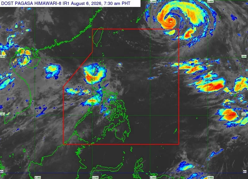
MANILA, Philippines — Tropical Storm Maymay (international name: Kujira) moved over Bangued, Abra on Thursday morning after making landfall in Magsingal, Ilocos Sur before dawn, PAGASA said.
In its 8 a.m. bulletin on Thursday, August 6, the state weather bureau said Maymay was carrying maximum sustained winds of 65 kilometers per hour near the center, gusts of up to 110 kph and a central pressure of 998 hectopascals.
The tropical storm is moving eastward at 10 kph.
Wind signals
The following areas are under Signal No. 2:
- Ilocos Norte
- northern and central portions of Ilocos Sur (Gregorio del Pilar, Magsingal, San Esteban, Banayoyo, Cervantes, Burgos, City of Candon, Santa Lucia, Santiago, San Vicente, Santa Catalina, Lidlidda, Nagbukel, Sinait, Suyo, Sigay, San Ildefonso, Galimuyod, Quirino, City of Vigan, San Emilio, Cabugao, Caoayan, San Juan, Santa, Bantay, Santo Domingo, Tagudin, Santa Cruz, Santa Maria, Narvacan and Salcedo)
- western portion of Apayao (Conner, Kabugao and Calanasan)
- Abra
- western and central portions of Kalinga (Pasil, Tinglayan, Balbalan, Lubuagan, Pinukpuk, City of Tabuk and Tanudan)
- western and central portions of Mountain Province (Besao, Tadian, Bauko, Sagada, Sabangan, Bontoc, Sadanga, Barlig and Natonin)
Under Signal No. 2, gale-force winds of 62 to 88 kph may be experienced within 24 hours, posing a minor to moderate threat to life and property.
Meanwhile, the following areas are under Signal No. 1:
- rest of Ilocos Sur
- La Union
- northwestern portion of Pangasinan (Bolinao, Anda and Bani)
- rest of Apayao
- rest of Kalinga
- rest of Mountain Province
- Ifugao
- Benguet
- southern portion of the Babuyan Islands (Calayan Island, Dalupiri Island, Fuga Island and Camiguin Island)
- mainland Cagayan
- Isabela
- Quirino
- Nueva Vizcaya
- northern and central portions of Aurora (Dilasag, Casiguran, Dinalungan and Dipaculao)
Under Signal No. 1, strong winds of 39 to 61 kph may be experienced within 36 hours, posing minimal to minor threats to life and property.
PAGASA said the southwest monsoon and the outer circulation of Maymay will continue to bring strong to gale-force wind gusts over most parts of the country through Saturday, particularly in coastal and upland areas.
Heavy rainfall
PAGASA said Tropical Storm Maymay and the southwest monsoon (habagat) will continue to bring heavy rainfall over parts of Luzon in the coming days.
Thursday, August 6
Tropical Storm Maymay
- 100-200 mm: Ilocos Sur, La Union, Benguet and Pangasinan
- 50-100 mm: Ilocos Norte, Abra, Apayao, Mountain Province, Ifugao, Kalinga, Nueva Vizcaya, Tarlac, Nueva Ecija, Zambales, Bataan, Pampanga and Bulacan
Southwest monsoon or habagat
- 50-100 mm: Metro Manila, Rizal, Cavite, Laguna, Batangas and Occidental Mindoro
Friday, August 7 – Habagat
- 100-200 mm: Occidental Mindoro
- 50-100 mm: Ilocos Sur, La Union, Pangasinan, Benguet, Zambales, Bataan, Cavite, Batangas and Antique
Saturday, August 8 – Habagat
- 100-200 mm: Zambales, Bataan, La Union, Benguet and Occidental Mindoro
- 50-100 mm: Ilocos Norte, Ilocos Sur, Pangasinan, Abra, Tarlac, Pampanga, Cavite, Batangas and Antique
PAGASA warned that flooding and rain-induced landslides remain possible, particularly in areas highly susceptible to these hazards. The weather bureau also reminded the public that heavy rainfall may still occur outside the forecast track of the tropical cyclone.
Sea conditions
A gale warning remains in effect over the western seaboard of Northern Luzon.
Very rough seas of up to 4.5 meters are forecast over the seaboards of Ilocos Sur, La Union, Pangasinan, western Ilocos Norte and northern Batanes. Sea travel is risky for all types of vessels, and mariners are advised to remain in port or seek shelter.
Rough seas of up to 4 meters are expected over the remaining seaboards of Batanes, the Babuyan Islands and the northeastern coast of mainland Cagayan. Seas of up to 3 meters are also forecast over the remaining seaboards of Ilocos Norte and mainland Cagayan, the eastern coasts of Isabela and northeastern Aurora, and the western seaboards of Zambales, Bataan and northwestern Occidental Mindoro.
PAGASA advised operators of small vessels and motor bancas not to venture out to sea in areas with rough seas and to take precautionary measures in areas with moderate sea conditions.
Track, intensity
PAGASA said Maymay will continue crossing the mountainous terrain of Northern and Central Luzon before emerging over the eastern coastal waters of Isabela or Cagayan.
The tropical storm is forecast to weaken into a tropical depression later Thursday morning and may further weaken into a remnant low by Thursday afternoon or evening. However, PAGASA said its interaction with the rugged terrain could cause it to weaken earlier than forecast.
The remnant low is expected to move generally southeastward before merging with the larger circulation of Tropical Cyclone Dolphin.
- Latest
- Trending