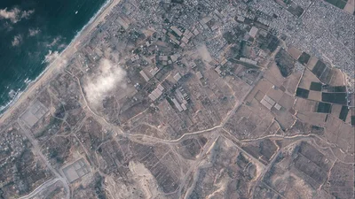
The Israeli military is quietly but quickly building a giant earth barrier separating the more than 50% of the Gaza Strip it controls from the rest of the territory, according to satellite imagery, further entrenching the division of the tiny Palestinian enclave.
More than 14 miles have been constructed in recent months, running through Palestinian communities demolished by the military.
That is equivalent to more than half the length of the coastal strip, which is some 25 miles long and seven miles wide, and home to more than two million Palestinians.
When presented with the satellite images, Israel’s military confirmed to The Associated Press it has built a physical barrier in the area of the so-called yellow line, the boundary to which Israeli troops withdrew under the October ceasefire deal with Hamas.
The line was envisioned in the US-backed agreement as a temporary division of the territory pending a fuller Israeli withdrawal.
A section of an earth barrier being built by the Israeli military. To the left is the demolished town of Beit Lahia and to the right a defunct sewage treatment plant (Planet Labs PBC/AP)
But as the truce stagnates, it appears Israel is digging in, heightening Palestinian fears that the line is morphing into a border.
Neither US Central Command, which is tasked with monitoring the ceasefire, nor the Board of Peace, the body led by US President Donald Trump meant to eventually oversee Gaza, would comment on the barrier.
The military also told AP it has developed a “security zone” around the line, equipped with intelligence and technological assets.
It declined to give details on the route of the barrier when asked how far it would be extended. It said the barrier aimed to prevent infiltration and protect Israeli troops and Israeli communities near Gaza.
Since the ceasefire deal took hold, Palestinians in Gaza have feared Israel would not return the area of Gaza it controls.
But few appear to be aware of the earth barriers now being built around them, because of the danger of even approaching that area.
A portion of the earth barrier network in southern Gaza was extended by more than 1.2 miles in two weeks this month, according to the satellite images provided by Planet Labs PBC.
It was about 0.3 miles long on July 1. By July 15, it was about 1.5 miles, splicing the Israel-controlled ruins of the city of Rafah from Muwasi, site of some of the largest Palestinian tent camps.
Destroyed buildings after an Israeli airstrike in Nuseirat, central Gaza Strip (Abdel Kareem Hana/AP)
If construction continues in its current direction, it will join up with the longest stretch of the barrier, which runs nearly unbroken for about 10 miles from the southern city of Khan Younis to near Gaza City, in the north.
Construction began on that stretch in February, and it appears work to extend it further south is continuing, according to the satellite images.
More than 0.6 miles was added between June 21 and July 7, running close to an Israeli military base built on the ruins of the town of Bani Suheila, near Khan Younis.
In the far north of Gaza, several unconnected stretches of barriers run just outside the largely levelled town of Beit Lahia.
The height in each place remains unclear. In some places, the barriers appear to run outside the yellow line.
Israel has mostly destroyed and depopulated the half of Gaza it controls
Gaza’s population has been crowded into the coastal area west of the yellow line, most living in squalid tent camps and dependent on aid.
On the other side of the line, satellite imagery shows that Israeli forces have levelled the vast majority of buildings using bulldozers and explosives, virtually erasing several towns and Rafah, once home to more than a quarter million people.
They have carved new road networks and erected new bases on the ruins of Palestinian towns.
Agricultural land has also been destroyed.
The Israeli military says it is demolishing infrastructure used by Hamas.
The yellow line was never precisely defined, whether in the ceasefire deal or by Israeli or US officials, and it has been inconsistently marked on the ground.
The military told AP it is working to clearly mark the route of the yellow line to “reduce friction and prevent harm to uninvolved individuals”.
Israeli forces have killed Palestinians who came close to the line or crossed it.
The Israeli military says it fires on those believed to be militants threatening its troops.
But those killed have included children and other civilians seemingly unaware of the line.
Some soldiers have said they do not always know who they are firing on and have orders to kill anyone crossing the boundary.