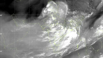
Over the past few days, the Indian Space Research Organisation (Isro)'s satellite images have shown clouds spreading further across India.
But the story has moved on. It is no longer about how much of the sky is grey. It is about how fiercely the weather underneath it is building.
WHAT HAS CHANGED OVER THE PAST FEW DAYS?
The latest INSAT-3DR and INSAT-3DS imagery, captured by Isro and read by the India Meteorological Department (IMD) in Delhi between 10.45 am and 11.27 am IST on July 21, 2026, shows cloud cover has pushed past 70 per cent of the country.
But the most telling change is not the spread. It is the depth.
Satellite imagery from July 21, 2026 shows monsoon clouds covering over 70 per cent of India, with the deepest storms over central and eastern India. (Photo: IMD)
Cloud Top Brightness Temperature readings over the Bay of Bengal, Odisha and West Bengal have dropped to minus 60 to minus 80 degrees Celsius, colder than they were a few days ago, marking storm towers now punching 12 to 16 kilometres into the atmosphere.
WHAT DOES COLDER CLOUD TOP TELL US ABOUT THE WEATHER?
Satellites cannot touch a cloud to take its temperature, so they read the infrared heat it gives off and convert that into a number called Cloud Top Brightness Temperature, or CTBT.
The trick works because thick cloud tops behave almost exactly like a blackbody, a surface that absorbs and re-emits radiation in a predictable way, a property confirmed by a widely cited 2014 study in the Journal of Applied Meteorology and Climatology.
Red and purple contours on the INSAT-3DR Cloud Top Brightness Temperature map mark storm tops colder than minus 60 degrees Celsius over the Bay of Bengal, Odisha and West Bengal. (Photo: IMD)
Since air in the troposphere cools by roughly 6.5 degrees Celsius for every kilometre gained in height, a colder reading simply means the cloud has grown taller.
That is why today's red and purple contours over the Bay of Bengal, Odisha and West Bengal, colder than minus 60 degrees, mark the most violent thunderstorm cores on the map, while the blue minus 40 degree bands over central India and the Gangetic plain mark steadier, less intense monsoon clouds.
WHAT DOES THIS MEAN FOR DELHI?
The national capital sits closer to the milder end of this picture, but it has not escaped it.
The monsoon trough, the low-pressure band that steers rainfall across the plains, was largely inactive over Delhi for a week or more before moisture from the Bay of Bengal reactivated it, and it now runs through the city.
Light rain lashed parts of Delhi-NCR on Tuesday morning as the monsoon trough reactivated over the capital, with the IMD issuing a yellow alert for more rain ahead. (Photo: PTI)
Light rain lashed several parts of Delhi-NCR this Tuesday morning, easing the hot, humid conditions of recent days, and the IMD has issued a yellow alert for the capital, forecasting a generally cloudy sky with spells of light to moderate rain, isolated heavy showers, thunderstorms and gusty winds over the next two days.
WHAT IS THE WATER VAPOUR CHANNEL SHOWING TODAY?
A separate INSAT-3DS image, tuned to 6.88 micrometres rather than cloud temperature, tracks moisture in the middle and upper atmosphere.
Today it shows a broad, bright band of saturated air over northern and central India and the Bay of Bengal, the reservoir feeding the taller storms further south and east.
The INSAT-3DS water vapour channel shows a bright band of moist air over northern and central India, feeding the storms tracked in the CTBT image. (GIF: IMD)
Dark patches over the Arabian Peninsula and western Pakistan show dry air sinking rather than rising, a sign that the monsoon's moisture supply, for now, is not coming under threat from that direction.
WHAT TO EXPECT OVER THE NEXT FEW DAYS
The IMD has forecast active monsoon conditions continuing over northwest and northeast India for four to five more days, with isolated heavy to very heavy rainfall likely over Odisha and Chhattisgarh, tracking closely with today's coldest cloud tops.
Cloud cover itself will keep fluctuating hour to hour as individual storm cells grow and collapse.
What is unlikely to ease off quickly is the intensity building beneath that cover, which is the real change satellites have picked up over the past few days.
- Ends
Published By:
Radifah Kabir
Published On:
Jul 21, 2026 14:11 IST