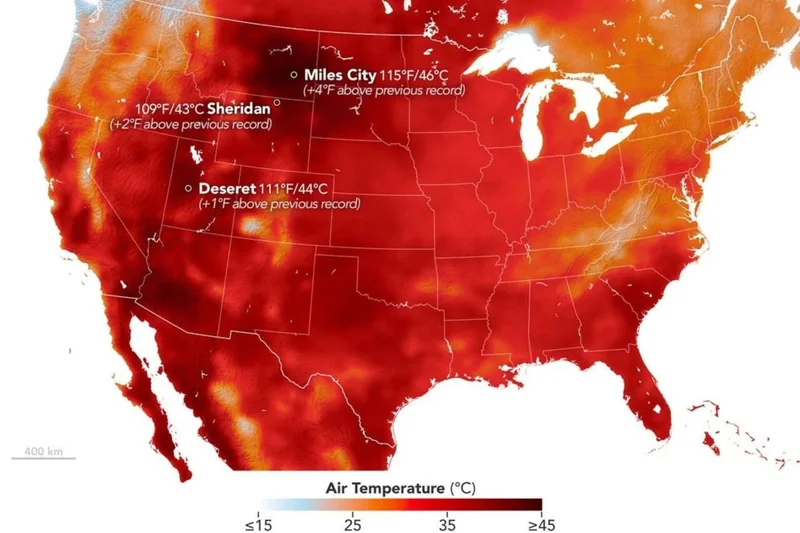
Both the contiguous United States and the world’s oceans just had their hottest July on record, according to newly released data. As carbon emissions and a “super” El Niño continue to worsen, scientists say last month was just a taste of what’s to come.
July 2026 averaged 76.9 degrees Fahrenheit (24.9 degrees Celsius) across the U.S., which is 3.3 degrees F (1.8 degrees C) above the 20th-century average and the highest average July temperature in the 132-year record, the National Oceanic and Atmospheric Administration reported Monday.
Copernicus, the Earth observation component of the European Union’s space program, published a separate analysis on Monday showing that the average sea surface temperature across oceans outside the polar regions was 69.73 degrees F (20.96 degrees C) in July, surpassing the previous July record of 69.6 degrees F (20.89 degrees C) set in 2023.
These historic temperatures have elicited alarm from experts, who have been warning for weeks that the combined impact of human-driven warming and El Niño could briefly make 2026 the hottest year on record before 2027 overtakes it.
âItâs not good when youâre breaking records from the Dust Bowl, which we are in this case,â meteorologist Jeff Masters of Yale Climate Connections told the Associated Press. “If weâre exceeding records from The Dust Bowl, that says that weâre in deep trouble.â
A sizzling July for the U.S.
Heat domes, drought conditions, and wildfires made national headlines last month. Among the extreme weather events noted in NOAA’s report were wildfires in eastern Oregon that burned more than 140,000 acres, the warmest July 4 ever recorded in multiple Mid-Atlantic cities, and extreme overnight temperatures across the Southwest.
According to NOAA, record-breaking nighttime lows were the biggest driver of July’s historic heat. Research has shown that hotter nights are a classic sign of climate change and a significant public health threat.
âExtremely high temperatures across the continental U.S. this summer, along with intense drought and fire conditions, are absolutely consistent with the climate change signal,” Katharine Jacobs, a climate scientist at the University of Arizona, told the AP.
NOAA expects above-average temperatures to persist through August across the central and southern tiers of the country. Heat advisories are currently in effect for much of the central and southeastern U.S. as yet another heat dome migrates east.
Drought should persist and expand across parts of the Northwest and east of the Rocky Mountains, including portions of the Great Plains and Upper Midwest. Significant woodland fire potential should also remain above normal in the Northwest, the Great Basin and central Rockies, parts of the northern and southern Plains, the Lower Mississippi Valley, and southern Florida.
On Monday, nearly 30,000 firefighters were battling 98 large, uncontained blazes nationwide, roughly half of which were burning in the  Northwest, according to the National Interagency Fire Center.
El Niño’s global impact
On top of the long-term warming trend driven by fossil fuel emissions, an unprecedented El Niño is set to boost Earth’s average temperature to new heights. This is the warm phase of the El Niño-Southern Oscillation, the largest and most influential year-to-year climate variation on the planet.
El Niño occurs when sea surface temperatures in the central and eastern equatorial Pacific Ocean rise above average, releasing a lot of excess heat into the atmosphere. Even in a typical El Niño year, this phenomenon significantly raises global temperatures and alters weather patterns around the world. But this is no typical El Niño.
The latest outlook from the European Centre for Medium-Range Weather Forecasts (ECMWF) shows this event peaking around 7.2 degrees Fahrenheit (4 degrees Celsius) in December, which would make this El Niño the strongest on record by a wide margin.
According to Copernicus, current El Niño conditions helped fuel the record-breaking global sea surface temperatures observed in July. It’s possible that a new record could be set very soon as El Niño continues to strengthen over the coming months.
Above-average ocean temperatures drive sea level rise by causing seawater to expand. At the same time, hotter oceans can lengthen and intensify marine heatwaves, leading to mass coral bleaching events, kelp forest die-offs, and other significant ecosystem impacts. Around Europe, record-high sea surface temperatures along the Atlantic and western Mediterranean were associated with widespread strong or marine heatwaves in July, Copernicus reports.
As experts take stock of last month’s historic heat, they are also looking ahead to an alarming future. El Niño’s worst impacts on global weather and temperatures won’t manifest for several more months. Fortunately, its effect will be temporary, but the impact of rising carbon emissions won’t be. Without significant, internationally coordinated intervention, “this may be one of the coolest years weâre gonna experience for the rest of our lives,” Masters said.