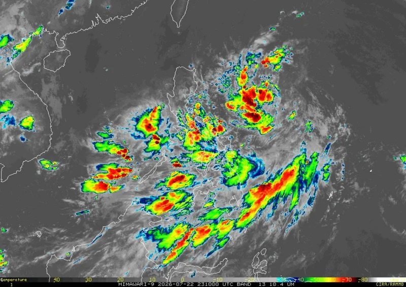
MANILA, Philippines — Tropical Depression Kiyapo slightly accelerated as it moved northwestward over the Philippine Sea east of Northern Luzon on Thursday morning, while Tropical Cyclone Wind Signal No. 1 remained hoisted over parts of Northern Luzon.
In its 11 a.m. bulletin on Thursday, July 23, PAGASA said Kiyapo was estimated at 830 kilometers east of Northern Luzon, with maximum sustained winds of 45 kilometers per hour near the center, gustiness of up to 55 kph and a central pressure of 1002 hectopascals.
The tropical depression is moving northwestward at 25 kph.
Wind signals. The following areas remain under Signal No. 1:
- Batanes
- Cagayan, including the Babuyan Islands
- Isabela
- Apayao
- Abra
- Kalinga
- Eastern and central portions of Mountain Province (Paracelis, Natonin, Barlig, Sadanga, Bontoc, Besao and Sagada)
- Eastern and central portions of Ifugao (Mayoyao, Aguinaldo, Alfonso Lista, Banaue, Hingyon, Lagawe and Lamut)
- Ilocos Norte
- Northern portion of Ilocos Sur (Cabugao, Sinait, San Juan, Magsingal, Santo Domingo, Bantay, San Ildefonso and San Vicente)
- Northern portion of Aurora (Dilasag and Casiguran)
- Northern portion of Quirino (Aglipay, Maddela, Cabarroguis, Saguday and Diffun)
- Northernmost portion of Nueva Vizcaya (Bagabag and Diadi)
Under Signal No. 1, strong winds ranging from 39 to 61 kph may be experienced within 36 hours, posing minimal to minor threats to life and property.
PAGASA said the highest wind signal that may be raised during Kiyapo's passage is Signal No. 2, although Signal No. 3 remains possible should the cyclone intensify into a severe tropical storm while traversing the Batanes-Babuyan Islands area.
Strong winds. PAGASA said the southwest monsoon enhanced by Kiyapo will bring strong to gale-force gusts over most of Mindanao, Siquijor, Bohol and Southern Leyte on Thursday, particularly in coastal and upland areas exposed to winds.
By Friday, July 24, strong to gale-force gusts are expected over most of the country. On Saturday, July 25, these conditions may affect most of Luzon, most of Visayas, Zamboanga del Norte, Davao Oriental and Dinagat Islands.
Sea conditions. PAGASA said a gale warning may be issued later Thursday or early Friday over the seaboards of Extreme Northern Luzon.
Rough seas with waves of up to 3 meters are expected over the eastern seaboards of Batanes and Davao Oriental, where small seacraft, including motor bancas, are advised not to venture out.
Moderate to rough seas with waves of up to 2.5 meters are forecast over the eastern seaboards of the Babuyan Islands, mainland Cagayan and Surigao del Sur, while waves of up to 2 meters are expected over the seaboards of Isabela, Davao Occidental, Sarangani, Sultan Kudarat, Maguindanao del Norte, Dinagat Islands and Siargao-Bucas Grande Islands, as well as the remaining seaboards of Batanes and the Babuyan Islands.
PAGASA advised operators of motor bancas and similarly sized vessels to take precautionary measures and, if possible, avoid navigating in affected waters.
Track, intensity. PAGASA said Kiyapo will continue moving west-northwestward until Saturday toward the Luzon Strait before turning northwestward.
The tropical depression may pass very close to the northeastern portion of mainland Cagayan between Friday morning and afternoon, then pass very close to or make landfall in the vicinity of the Babuyan Islands between Friday afternoon and evening.
It is forecast to exit the Philippine Area of Responsibility by Saturday morning or noon.
Kiyapo is expected to gradually intensify over the Philippine Sea and may reach tropical storm category on Friday.
It may further strengthen into a severe tropical storm after passing the Babuyan Islands before weakening as it makes landfall over southern mainland China and moves farther inland.