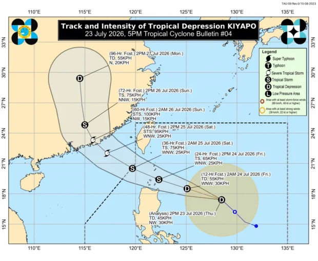
Track and intensity forecast of Tropical Depression Kiyapo as of 5 p.m. on July 23, 2026. Image from DOST / Pagasa
MANILA, Philippines — Tropical Cyclone Wind Signal (TCWS) No. 1 was raised over parts of Northern Luzon due to Tropical Depression Kiyapo on Thursday afternoon, the state weather bureau said.
In the 5 p.m. bulletin of the Philippine Atmospheric, Geophysical, and Astronomical Services Administration (Pagasa), the following areas are placed under TCWS No.1:
READ: Pagasa: Wind Signal No. 1 raised over parts of N. Luzon due to Kiyapo
Article continues after this advertisement
- Batanes
- Cagayan including Babuyan Islands
- Isabela
- Apayao
- Abra
- Kalinga
- Mountain Province
- Ifugao
- Ilocos Norte
- Ilocos Sur
- Northern portion of Aurora (Dilasag, Casiguran, Dinalungan)
- Northern portion of Nueva Vizcaya (Bagabag, Diadi, Bayombong, Ambaguio, Villaverse, Quezon, Solano)
- Northern portion of Quirino (Maddela, Cabarroguis, Saguday, Diffun, Aglipay)
- Northern portion of Benguet (Buguias, Mankayan, Bakun, Kibungan)
With this, Pagasa warned of “minimal to minor threat to life and property” as wind speeds range from 39 kilometers per hour (kph) to 61 kph.
READ: Kiyapo putting 6,947 barangays at risk of landslides, floods – OCD
Meanwhile, Kiyapo maintained its strength as it was still carrying a maximum wind speed of 45 kph and gustiness of up to 55 kph. It accelerated as it was moving northwestward at 25 kph.
It added that the southwest monsoon or habagat and Kiyapo’s periphery will bring strong to gale-force gusts over the following areas:
- Thursday: Most of Mindanao, Suquijor, Bohol, and Southern Leyte
- Friday: Most of the country
- Saturday: Most of Luzon and Visayas, Zamboanga del Norte, Davao Oriental, and Dinagat Islands
/jpv
Your subscription could not be saved. Please try again.
Your subscription has been successful.