The surface of Mars is home to some of the most breathtaking and awe-inspiring landscapes in the solar system. This is primarily due to the Red Planet lacking several re-surfacing processes that Earth possesses, including plate tectonics, volcanism, and flowing water. While Mars does have dust storms, this has done little to reshape the planetâs surface, which has remained largely undisturbed for billions of years. However, this near-pristine landscape has enabled scientists to look back in time while slowly piecing together what Mars was like long ago.
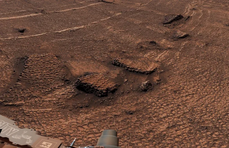
Now, NASAâs Mars Curiosity rover recently beamed back images of a landscape featuring polygon-like features, which is a unique landscape that has been observed on other regions of Mars but was a first-time observation for the car-sized rover. It is hypothesized that these polygonal features form as mud cracks, a process that was discussed in a 2023 study published in Nature which those researchers hypothesized formed from intense wet-dry cycles from Curiosity rover observations within Gale Crater.
That study concluded by noting those mud cracks could have formed during whatâs known as the Noachian-Hesperian transition, which occurred about 3.8 to 3.6 billion years ago and which researchers have hypothesized is when Mars could have exhibited an Earth-like climate. However, the researchers for these new polygonal features suggest more work is needed to know their formation processes, whose diameters have been measured at about 4 to 8 centimeters (1.5 to 3 inches) across.
âWeâve seen a lot of fascinating landscapes through Curiosityâs eyes, but this sea of polygons took our breath away,â said Dr. Ashwin Vasavada, who is a Curiosity rover mission scientist at NASAâs Jet Propulsion Laboratory. âWe measured their shapes and chemistry carefully and are hopeful there are clues in the data as to how these features formed.â
As noted, polygonal features have been observed across Mars. While these latest polygons are hypothesized to have formed as mud cracks, polygons in other regions of Mars are hypothesized to have formed from freeze-thaw cycles or from tectonic or volcanic stress. While Gale Crater isnât the only region on Mars where mud cracks have been observed, it is the only region observed at ground-level by a rover.
Other polygonal surface features have been observed across Mars by orbiters, specifically NASAâs High Resolution Imaging Science Experiment (HiRISE) orbiter. HiRISE has been orbiting Mars since 2006 while providing arguably some of the most breathtaking images of the Red Planet. The primary difference between ground-level observations and orbiter observations are the size of the polygons, with ground-level polygons having been observed to be about the size of the recently observed polygons by Curiosity, whereas polygons observed by orbiters are much larger, ranging between 15 to more than 350 meters (50 to over 1,000 feet) in diameter.
Examples of regions on Mars that display large polygons occur in features known as crater floor polygons (CFPs), which display large, cracked surfaces potentially indicative of past standing water. These regions featuring CFPs include Hellas Planitia, Noachis Terra, and Margaritifer Terra, with Hellas Planitia being the largest impact basin on Mars measuring about 2,300 kilometers (1,400 miles) in diameter and a depth of just over 7,000 meters (23,000 feet) beneath the Mars datum, or the zero point elevation for Mars.
Today, Mars is a cold and dry planet with its surface still displaying processes that potentially occurred billions of years ago during the planetâs Pre-Noachian, Noachian, and possibly Hesperian periods, which is estimated to have collectively spanned between 4.5 and 3.0 billion years ago, with the current period being the Amazonian Period.
What new insights into polygon terrain on Mars will scientists make in the coming years and decades? Only time will tell, and this is why we science!
As always, keep doing science & keep looking up!