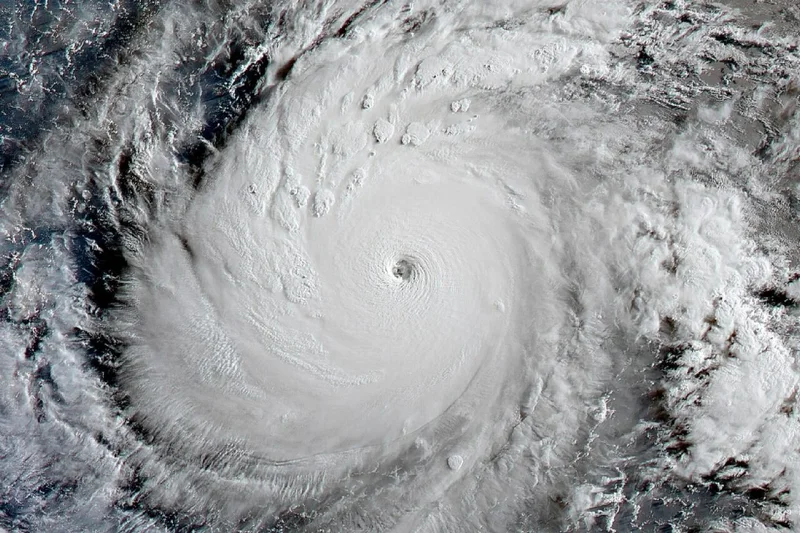
The U.S. may be enjoying a quiet Atlantic hurricane season thanks to a growing “super” El Niño, but don’t let that fool you. This climatic phenomenon is supercharging storm activity over the Pacific Oceanâso much so that Earth is on track for a record-breaking year of Category 5 hurricanes.
Super typhoon Dolphin is the fifth Cat 5 tropical cyclone of 2026, putting this year ahead of the pace set in 1997, which currently holds the all-time global record for the most Cat 5 storms in a single year. A very strong El Niño encouraged the development of 12 Cat 5s that year, 10 in the Northwest Pacific and two in the Northeast Pacific.
The system that would become Dolphin went through two bouts of rapid intensification in the Northwest Pacific this week: one between Monday and Tuesday and another late Wednesday, meteorologists report for Yale Climate Connections. Though forecasters do not officially use the Saffir-Simpson Hurricane Wind Scale to categorize typhoons, Dolphin’s maximum sustained wind speed peaked at 165 miles per hour (270 kilometers per hour) on Thursday morning local time, which is equivalent to a Category 5 hurricane.
Dolphin has since weakened slightly but remained a super typhoon in the North Pacific late Friday Japan Time, according to the latest advisory from the Joint Typhoon Warning Center. The storm does not currently pose an immediate threat to land. Meanwhile, Tropical Storm Genevieve, which was downgraded after reaching Cat 5 strength on Monday, is steadily weakening and moving farther away from Mexico’s Pacific Coast.
The Cat 5 storms that preceded Dolphin and Genevieve were Tropical Cyclone Horacio on February 23, Super Typhoon Sinlaku on April 12, and Super Typhoon Bavi on July 5, all of which formed over the Pacific.
How El Niño supercharges Pacific hurricanes
In May, the National Oceanic and Atmospheric Administration predicted above-normal hurricane activity in both the central and eastern Pacific basins this year, largely due to an oncoming El Niño. This is the warm phase of the El Niño-Southern Oscillation, a recurring climate pattern involving changes in sea surface temperatures in the central and eastern tropical Pacific Ocean. During El Niño, water temperatures rise above average, altering weather patterns across the globe.
The still-developing 2026-2027 El Niño is on track to become the strongest on record by a long shot. Peak temperatures in the tropical Pacific Ocean could rise about 6.5 degrees Fahrenheit (3.6 degrees Celsius) above average. Thatâs 1.4 degrees F (0.8 degrees C) above the previous record set during the 2015-2016 super El Niño.
All that extra heat provides ample fuel for storms to organize and strengthen, increasing the likelihood that strong tropical cyclones will form. At the same time, El Niño reduces vertical wind shear, which favors more hurricane activity in the Pacific. This phenomenon has the opposite effect on the Atlantic, suppressing tropical storm formation.
Fortunately for the U.S., Pacific hurricanes tend not to make landfall here. According to CBS meteorologist Zoe Mintz, “trade winds steer storms from east to west from the equator to the 30th parallel, meaning the East Coast gets slammed and the West Coast gets spared because the storms usually go out to sea.” Even if winds do push a tropical cyclone toward the West Coast, it will weaken as it encounters the chilly waters of the California current, Mintz explains.
Still, the hyperactive state of the Pacific is a sign of the incredible impact this growing super El Niño is already having on global weather. If this trend continues, there’s a good chance 2026 will steal the record for the most Category 5 storms in a single year.