Seven fortresses, one strategy: How the Alamut defensive network worked
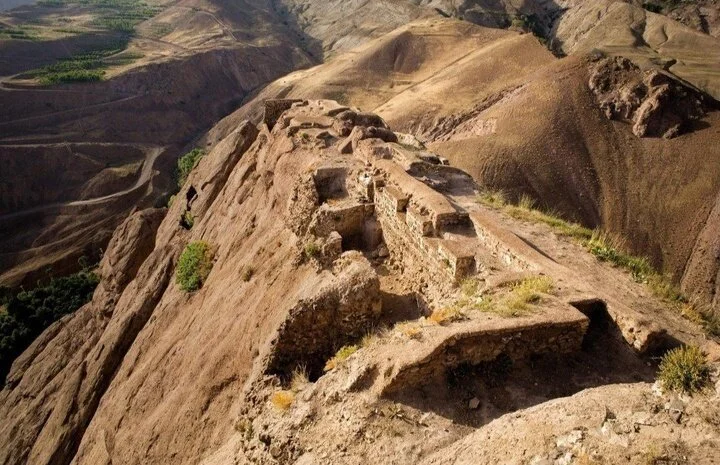
TEHRAN - When the name Alamut is mentioned, many people picture a castle standing atop a towering cliff. However, what has now been inscribed on UNESCO’s World Heritage List as “Alamut Castle and Related Fortifications” is far more than a single fortress. It is a complex network of seven mountain strongholds that, between the 11th and 13th centuries CE, formed one of the most advanced defensive systems of medieval Iran through the combined use of geography, architecture, water management and spatial organization.
The outstanding value of this heritage lies precisely in this network-based approach: a system that UNESCO recognizes as an exceptional example of strategic organization, resilience and adaptation to a challenging mountainous environment.
More than 900 years ago, on the southern slopes of the Alborz Mountains, the planners of Alamut viewed security as a network. Each fortress was part of a larger system, and no individual stronghold had meaning in isolation.
The UNESCO World Heritage nomination dossier emphasizes this very characteristic. It describes “Alamut Castle and six associated fortifications” as a serial heritage property consisting of Alamut, Lambesar, Noweizar Shah, Shams Kalayeh, Qestīnlar, Shirkuh and Ilan, all located at strategic points across the Alborz mountain range.
According to Miras Aria news agency, the secret behind this network first lay in the selection of locations. Almost all of these fortifications were built on high cliffs or narrow mountain ridges, at points accessible through only one or two restricted routes. Such positioning forced attackers to approach the castle walls through steep, narrow and easily controlled paths.
But natural advantages were only part of the story. Each fortress overlooked communication routes through the Alamut valleys and mountain passes of the Alborz. This strategic placement allowed inhabitants to monitor the movement of troops, caravans and military forces and to prepare for potential threats. UNESCO research describes the complex as a network with an advanced spatial and strategic organization.
Contrary to common perceptions, what distinguished this network was its ability to sustain life during periods of siege. According to the UNESCO nomination dossier, one of the most important features of these fortifications was their advanced water and food management systems. Cisterns, storage facilities, water channels fed by springs and seasonal rainfall, as well as the use of surrounding lands for agricultural production, enabled long-term resistance.
In reality, Alamut functioned as a small city on the mountain. Within the fortifications were residential areas, grain storage facilities, water reservoirs, service spaces and quarters for personnel, allowing life to continue during times of crisis without immediate dependence on the outside world.
Another important feature of this system was the principle of dispersion combined with connectivity. Rather than concentrating all defensive power in a single location, several fortresses were established at different points so that if one came under pressure, other strongholds could remain operational. This resembles what modern military studies describe as “network resilience,” although the modern term should not be directly applied to a historical structure. Available evidence suggests that the distribution of fortresses reduced the likelihood of the entire system collapsing simultaneously.
Lambesar, the second most important fortress in the complex, provides a clear example of this strategy. One of the largest castles in the region, it controlled important western routes and, together with Alamut, formed part of the backbone of the defensive network. Other fortifications were similarly positioned to oversee valleys, mountain passes or access routes.
However, a distinction must be made between historical facts and legends. Numerous stories exist about communication methods between the castles, including the use of fires, smoke signals or carrier pigeons, but many of these accounts lack conclusive archaeological evidence or contemporary documentation. For this reason, the UNESCO nomination focuses not on such narratives, but on proven characteristics such as defensive architecture, spatial organization, water resource management and adaptation to the natural environment.
Another reason for the durability of this network was its complete adaptation to the mountainous landscape. The architects of Alamut sought to use the rock itself as part of the fortifications wherever possible. In many places, natural cliffs replaced artificial walls, while walls and towers were constructed only where necessary. This integration of architecture and nature both reduced construction demands and made penetration more difficult.
UNESCO has also highlighted this feature in its statement of Outstanding Universal Value, describing the property as an exceptional example of the adaptation of defensive architecture to the mountainous landscape of the Alborz, where the natural environment itself became part of the defensive design.
From the late 11th century CE, Alamut became the political, military, scientific and intellectual center of the Nizari Ismailis. This dual character, the coexistence of defensive and cultural functions, was among the main reasons for its inscription on the World Heritage List. UNESCO notes that, in addition to its protective role, the network also served as a center of knowledge, thought and cultural life.
In 1256 CE, the Mongol invasion led to the fall of Alamut Castle. However, the end of its political role did not mark the end of its historical significance. What remains today is evidence of a different approach to defense, resource management and territorial organization.
Alamut Castle and Related Fortifications was inscribed on UNESCO’s World Heritage List during the 48th session of the UNESCO World Heritage Committee in Busan, South Korea, becoming Iran’s 30th tangible cultural heritage property to receive the designation.
The Alamut fortifications were eventually captured by Mongol ruler Hulagu Khan in 1256 through a combination of military pressure and diplomatic maneuvering, after he had forced the surrender of the Ismaili spiritual leader, the successor of Hassan-i Sabbah.
For centuries, Alamut Castle was largely forgotten and only returned to wider public attention after the publication of British explorer Freya Stark’s 1930s travel book The Valleys of the Assassins. A copy of the recently reprinted volume remains a popular companion for visitors exploring the region.
AM