Under fire for the sluggish response to the rain-related calamities in the State over the last few days, the State government on Monday sought to blame the India Meteorological Department (IMD) for a delay in relaying the weather forecast. But experts say it also unravels the absence of long-term mitigation plans to tackle increasingly frequent rain-induced calamities in the State.
Chief Minister V.D. Satheesan on Monday said the flooding was triggered by extremely heavy rainfall, with some places receiving more than 350 mm of rain. He said the State received the IMD’s warning of an extreme rainfall event only around midnight, leaving little time for authorities to carry out large-scale evacuations.
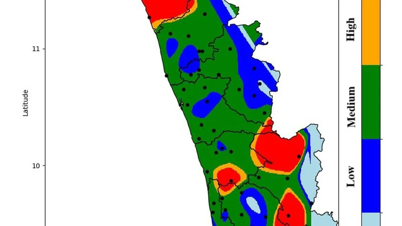
However, the IMD’s 125-year rainfall dataset, covering 110 weather stations across Kerala from 1901 to 2025, shed enough light on the State’s most vulnerable regions during the monsoon, including areas prone to extreme rainfall. Using this historical dataset with machine learning and Geographic Information System (GIS) techniques, weather scientists have prepared a rainfall vulnerability map that highlights several disaster-prone regions.
Colour-coded zones
The map shows that many parts of north Kerala, Idukki and Pathanamthitta, particularly areas along the Western Ghats, are highly susceptible to extreme rainfall events. The map categorises the State into different colour-coded zones based on rainfall intensity. Areas marked in red have experienced extreme rainfall events repeatedly over the past 125 years, while orange zones receive heavy rainfall of lower intensity. Green, blue and light blue represent progressively lower rainfall categories.
Notably, the recent weather events in Idukki, Pathanamthitta and Kottayam, as well as the debris slip in Wayanad last month that claimed eight lives, occurred in areas classified as red zones. According to weather experts, these regions become particularly vulnerable whenever the offshore trough extends up to Kerala along India’s west coast. Their geographical characteristics, combined with prevailing monsoon conditions, make them highly susceptible to heavy and very heavy rainfall, they say. The State need not wait for weather alerts to be upgraded before initiating preparedness measures.
The challenges
According to Thara K.G., a geologist and disaster management expert, rainfall warnings are only one component of disaster preparedness. Kerala’s biggest challenge is the absence of a long-term disaster mitigation strategy. “The State cannot evacuate an entire population solely based on rainfall alerts,” she said. “What Kerala lacks is a comprehensive long-term plan to reduce the impact of extreme weather events. This problem is further aggravated by the absence of effective land-use planning,” said Ms. Thara.
A senior official associated with the Kerala State Disaster Management Authority said implementing major policy reforms remains difficult in a densely populated State like Kerala. Measures such as enforcing land-use regulations or removing accumulated silt, sand and soil from rivers and other waterbodies often face significant resistance. “Strong policy-level intervention is essential to bring about meaningful reforms in the sector,” the official said.
Published - August 04, 2026 05:45 am IST