Pagasa tracks 2 tropical cyclones boosting habagat
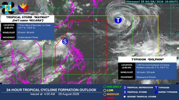
LAPU-LAPU CITY, Cebu — The state weather bureau is monitoring two tropical cyclones within and outside the Philippine Area of Responsibility (PAR) on Wednesday, August 5.
The Philippine Atmospheric, Geophysical and Astronomical Services Administration (Pagasa) said both weather systems are enhancing the southwest monsoon, or habagat, bringing rains to western portions of the country.
In its daily outlook, Pagasa said rainy weather is expected over the western sections of Luzon and the Visayas for the rest of the week.
The rest of the country, including the eastern parts of Southern Luzon, Bicol Region, remaining areas of the Visayas, and Mindanao, will see localized thunderstorms throughout the day.
Localized thunderstorms are brief weather disturbances caused by intense surface heating.
Tropical Storm Maymay
Several areas in Luzon are currently under Tropical Cyclone Wind Signals (TCWS) due to Tropical Storm Maymay (international name: Kujira).
As of Wednesday morning, TCWS No. 2 has been raised over the following localities:
The central and southern portions of Ilocos Sur, the northern and central portions of La Union, the northwestern portion of Pangasinan, the southwestern portion of Abra, the western portion of Mountain Province, and the northwestern portion of Benguet.
READ: Super typhoon outside PAR weakens into typhoon
Pagasa has also raised TCWS No. 1 over these areas:
Ilocos Norte, the rest of Ilocos Sur, the rest of La Union, the rest of Pangasinan, Apayao, the rest of Abra, Kalinga, the rest of Mountain Province, Ifugao, the rest of Benguet, Cagayan, Isabela, Quirino, Nueva Vizcaya, the northern portion of Zambales, the northern portion of Tarlac, the northern portion of Nueva Ecija, and the northern portion of Aurora.
As of 3 a.m. Wednesday, Tropical Storm Maymay (international name: Kujira) was located 170 kilometers west-northwest of Bacnotan, La Union.
It was packing maximum sustained winds of 65 kilometers per hour near the center and gusts of up to 80 km/h.
Strong winds, seas
The bureau said the combined effects of the southwest monsoon and tropical storm will bring strong to gale-force gusts over most of Luzon and the Visayas, Surigao del Norte, Dinagat Islands, Misamis Occidental, Camiguin, Lanao del Norte, Sarangani, Davao Occidental, and Davao Oriental today.
Similar conditions are expected for most of the country from Thursday to Friday.
Meanwhile, Pagasa has raised a gale warning over the western seaboard of Northern Luzon, particularly along the coasts of Ilocos Sur, La Union, and Pangasinan.
The bureau said very rough seas of up to 4.5 meters are expected in these coastal waters, making sea travel risky for all types and tonnage of vessels.
Typhoon Dolphin
Pagasa continues to monitor Typhoon Dolphin outside PAR, which was located 1,845 kilometers east-northeast of Extreme Northern Luzon as of 3 a.m. Wednesday.
The typhoon was packing maximum sustained winds of 165 kilometers per hour and gusts of up to 205 km/h.
Pagasa said Dolphin may enter or pass near the northern portion of PAR in the coming days.
The weather bureau added that Dolphin could pull Tropical Storm Maymay eastward, causing it to cross parts of Luzon before eventually dissipating.
Disclaimer: The comments uploaded on this site do not necessarily represent or reflect the views of management and owner of Cebudailynews. We reserve the right to exclude comments that we deem to be inconsistent with our editorial standards.