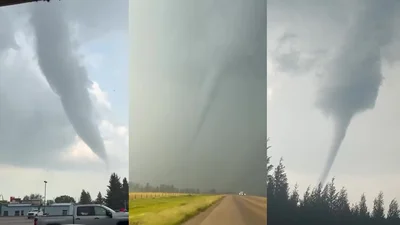
From torrential downpours to lighting and thunder and several tornadoes, Alberta is experiencing an active summer storm season.
As of July 21, there have been 26 tornadoes recorded in Alberta this year — an increase by over 50 per cent compared to previous years, according to the Northern Tornadoes Project based out of Western University in London, Ont.
Dr. David Sills is the director of the Northern Tornadoes Project at Western University’s Canadian Severe Storms Lab, as well as a former weather scientist at Environment Canada.
The NTP’s research team has been compiling data for nearly a decade and has been able to nearly double the 30-year average number of tornadoes documented across Canada on a regular basis.
Members of the team travel across Canada throughout the summer storm season when a tornado is suspected to have occurred, working with Environment Canada to document the twisters.
Story continues below advertisement
Sills spoke with Vinesh Pratap on Global News Morning Edmonton about the work his team does and what observations they’ve made about Alberta’s 2026 season.
Read the conversation below, which has been edited for clarity.
Vinesh Pratap: So just a little bit of background and history about the Northern Tornadoes project — what are you all about, how long have you been around, and take us through your work?
David Sills: We’ve been around since 2017 and we’ve done investigations nationally since 2019. Our goal is to detect, assess, and document every tornado that occurs across Canada, which is a big job. But we have a big enough team, enough resources to do that. And when something happens, like the tornadoes, say on Friday and Saturday in Alberta, we have teams out there investing.
Vinesh Pratap: Take us through — are you just investigating and recording the tornadoes and the touchdowns, or is a part of something larger, you know, tracking trends and whatnot?
David Sills: Oh, yeah, it’s all of the above. You know, we have to get the details of the tornado intensity, the length, the width, all of these things to be able to document it properly.
In the case of the Rocky Mountain House tornado, we’re trying to determine if it was more than one tornado — it may have been multiple tornadoes that caused the damage there. Once the damage was studied over the last couple of days, it became apparent that this is a complicated event. So it’s that kind of thing where we’re making sure we’re getting the most accurate documentation of the event possible.
Story continues below advertisement
Then you use the data for various things. You can do risk analysis — that informs the building code. You can do the performance and assessment of tornado warning program — we’ve done that, we had three report cards on that over the years. And also assess long-term trends and look at the possible influence of climate change.
1:44
Tornado hits Rocky Mountain House and Clearwater County
Vinesh Pratap: Okay, so let’s expand upon that. You know, you mentioned again the tornado project has been around since 2017. Climate change is a big concern for those in the meteorological community. What are you seeing? What concerns do you have?
Get daily National news
Get daily Canada news delivered to your inbox so you'll never miss the day's top stories.
David Sills: Well, one thing that’s likely happening is that the tornado season, the thunderstorm season is getting longer. It’s starting earlier, ending later. There’s more chances for severe thunderstorms to develop through the season, more chance for tornadoes. It’s expanding northward, too, as all of that warmer air starts moving further north.
We know there’s going to be changes to the storm season, to the tornado season in Canada. We’re trying to figure out exactly why or where things change. It’s not as easy, as climate change equals more tornadoes. Some areas are going to experience more, some maybe less. In fact, when we look at the long-term trends since 1980, it does appear that on the Prairies, the number of tornadoes is actually decreasing while in Ontario and Quebec it’s increasing.
Story continues below advertisement
But of course, the year-to-year variability is very high. That’s why we have to look at a long record to smooth out all that variability and get an idea of the long-term trends. And this year certainly stands out as being potentially a record year for tornadoes in Alberta.
1:56
Northern Tornadoes Project searches for remote Canadian twisters
More on Weather
More videos
Vinesh Pratap: You know, I think for a lot of us here in Edmonton, born and raised or just have been here for a long time, we think back to the 1987 tornado — so our eyes are always to the sky. So take us through the advancements in technology when it comes to, you know, monitoring and sending out the watches and the alerts — because I want to give you the example.
There was that tornado in mid-June in the northwest part of the province where even Environment Canada said no (warnings) or watches were issued. Talk to us about the unpredictability, despite all the advances in technology forecasting.
Story continues below advertisement
David Sills: Just going back to the Edmonton tornado in 1987, there wasn’t a Doppler radar available at that time for forecasters to see a rotating thunderstorm that could produce a big tornado like the Edmonton tornado. So there have been advances there.
The Edmonton radar was one of the first to be Dopplerized in Canada so that we can see that kind of rotation of the storm. And in the ’90s all of the radars across the country were made Doppler radars. And just in the last several years, there was a new network of radars rolled out that not only can see winds in a thunderstorm, but actually can see the shape of precipitation — so you know if it’s heavy rain or hail or that kind of thing.
0:50
Black Friday Tornado: Edmonton marks sombre 30-year anniversary
So there have been these big technological advances in the hardware — not so much on the software side that helps to put high-quality images in front of forecasters. So we’re still dealing with problems of noisy images coming out of the radars — dropouts and that kind of thing that really needs more attention.
Story continues below advertisement
It’s a really tough job doing tornado warnings for the forecaster because the target lead time for a tornado warning is only 10 minutes. So the problem is, if you look at the radar and it’s not quite clear what’s going on, you can either just issue a tornado warning and you’re not sure if it’s actually happening or not — or you can wait for another scan, and that’s six minutes out of that 10 minutes. So it’s really very time sensitive.
Radar is the number one tool and there really needs to be more emphasis on getting high-quality radar images and products in front of forecasters so they can make more timely and accurate decisions about tornado warnings.
Vinesh Pratap: Well, there is a lot to monitor, and it’s important that people like you and your organisation exist to keep us informed. Thank you for joining us, it’s greatly appreciated.
David Sills: Thanks for having me.